IMAGES TAKEN NEAR TO
Lime Close, DRIFFIELD, YO25 6UN
Introduction
This page details the photographs taken nearby to Lime Close, YO25 6UN by members of the Geograph project.
The Geograph project started in 2005 with the aim of publishing, organising and preserving representative images for every square kilometre of Great Britain, Ireland and the Isle of Man.

There are currently over 7.5m images from over14,400 individuals and you can help contribute to the project by visiting https://www.geograph.org.uk
Image Map (Loading...)


Getting Data...Please wait
Leaflet Map data © OpenStreetMap
Images are licensed for reuse under creativecommons.org/licenses/by-sa/2.0
Notes
- Clicking on the map will re-center to the selected point.
- The higher the marker number, the further away the image location is from the centre of the postcode.
Image Listing (160 Images Found)
Images are licensed for reuse under creativecommons.org/licenses/by-sa/2.0
Image
Details
Distance
7
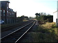
Railway towards Hull
Looking south west from the level crossing on Skerne Road.
Image: © JThomas
Taken: 20 Dec 2014
0.09 miles
9
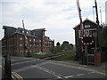
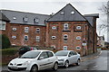
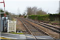
Level Crossing and converted mill. Driffield
Image: © Martin Dawes
Taken: 30 May 2012
0.09 miles
10

Flats in former mill on Skerne Road
From the level crossing on Skerne Road
Image: © JThomas
Taken: 20 Dec 2014
0.09 miles