IMAGES TAKEN NEAR TO
Beverley Road, DRIFFIELD, YO25 6SB
Introduction
This page details the photographs taken nearby to Beverley Road, YO25 6SB by members of the Geograph project.
The Geograph project started in 2005 with the aim of publishing, organising and preserving representative images for every square kilometre of Great Britain, Ireland and the Isle of Man.

There are currently over 7.5m images from over14,400 individuals and you can help contribute to the project by visiting https://www.geograph.org.uk
Image Map (Loading...)


Getting Data...Please wait
Leaflet Map data © OpenStreetMap
Images are licensed for reuse under creativecommons.org/licenses/by-sa/2.0
Notes
- Clicking on the map will re-center to the selected point.
- The higher the marker number, the further away the image location is from the centre of the postcode.
Image Listing (265 Images Found)
Images are licensed for reuse under creativecommons.org/licenses/by-sa/2.0
Image
Details
Distance

4

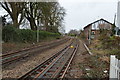
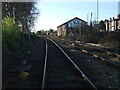
Railway towards Driffield Railway Station
Looking north east from the level crossing on Skerne Road.
Image: © JThomas
Taken: 20 Dec 2014
0.01 miles
5
Railway heading south west from Driffield Railway Station
From the level crossing on River Head.
Image: © JThomas
Taken: 20 Dec 2014
0.01 miles
6

Yorkshire Coast Line into Driffield Station
From the level crossing on Skerne Road.
Image: © JThomas
Taken: 24 Sep 2023
0.01 miles
7
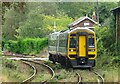
Train approaching Driffield Railway Station
Northern Class 158, No. 158784.
Image: © JThomas
Taken: 24 Sep 2023
0.01 miles