IMAGES TAKEN NEAR TO
Eastgate South, DRIFFIELD, YO25 6LW
Introduction
This page details the photographs taken nearby to Eastgate South, YO25 6LW by members of the Geograph project.
The Geograph project started in 2005 with the aim of publishing, organising and preserving representative images for every square kilometre of Great Britain, Ireland and the Isle of Man.

There are currently over 7.5m images from over14,400 individuals and you can help contribute to the project by visiting https://www.geograph.org.uk
Image Map
Images are licensed for reuse under creativecommons.org/licenses/by-sa/2.0
Notes
- Clicking on the map will re-center to the selected point.
- The higher the marker number, the further away the image location is from the centre of the postcode.
Image Listing (236 Images Found)
Images are licensed for reuse under creativecommons.org/licenses/by-sa/2.0
Image
Details
Distance
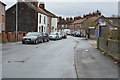
2
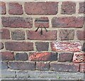
Driffield, 27 Eastgate
The benchmark is cut into the north-east face of the property.
Image: © Mel Towler
Taken: 28 Mar 2022
0.02 miles
3
Driffield, 27 Eastgate
There is a benchmark cut into the north-east face of the property.
Image: © Mel Towler
Taken: 28 Mar 2022
0.02 miles
7
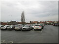
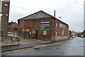
Old Cattle Market Carpark Driffield
Centre distant, the 15th century west tower of All Saints. 110ft high
Image: © Martin Dawes
Taken: 24 Nov 2020
0.05 miles
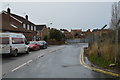
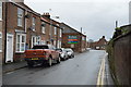
8
Wansford Road (B1249), Driffield
Heading north west.
Image: © JThomas
Taken: 20 Dec 2014
0.07 miles

10

Driffield Christian Fellowship
On Wansford Road (B1249).
Image: © JThomas
Taken: 20 Dec 2014
0.08 miles