IMAGES TAKEN NEAR TO
Bentley Close, YO25 6BF
Introduction
This page details the photographs taken nearby to Bentley Close, YO25 6BF by members of the Geograph project.
The Geograph project started in 2005 with the aim of publishing, organising and preserving representative images for every square kilometre of Great Britain, Ireland and the Isle of Man.

There are currently over 7.5m images from over14,400 individuals and you can help contribute to the project by visiting https://www.geograph.org.uk
Image Map
Images are licensed for reuse under creativecommons.org/licenses/by-sa/2.0
Notes
- Clicking on the map will re-center to the selected point.
- The higher the marker number, the further away the image location is from the centre of the postcode.
Image Listing (290 Images Found)
Images are licensed for reuse under creativecommons.org/licenses/by-sa/2.0
Image
Details
Distance
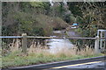
1
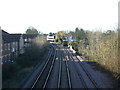
Railway into Driffield Station
Looking south west from the footbridge.
Image: © JThomas
Taken: 20 Dec 2014
0.01 miles

5
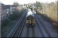
Railway near Driffield Station
Northern Rail Class 158, NO. 158904 heading for Scarborough.
Image: © JThomas
Taken: 20 Dec 2014
0.04 miles
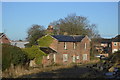
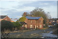
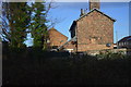
7
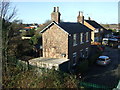
House on East Gate South, Driffield
Near the railway.
Image: © JThomas
Taken: 20 Dec 2014
0.04 miles
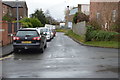
10
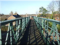
Footbridge over railway
As seen on http://www.geograph.org.uk/photo/4286123
Image: © JThomas
Taken: 20 Dec 2014
0.05 miles