IMAGES TAKEN NEAR TO
Union Street, DRIFFIELD, YO25 6AT
Introduction
This page details the photographs taken nearby to Union Street, YO25 6AT by members of the Geograph project.
The Geograph project started in 2005 with the aim of publishing, organising and preserving representative images for every square kilometre of Great Britain, Ireland and the Isle of Man.

There are currently over 7.5m images from over14,400 individuals and you can help contribute to the project by visiting https://www.geograph.org.uk
Image Map
Images are licensed for reuse under creativecommons.org/licenses/by-sa/2.0
Notes
- Clicking on the map will re-center to the selected point.
- The higher the marker number, the further away the image location is from the centre of the postcode.
Image Listing (245 Images Found)
Images are licensed for reuse under creativecommons.org/licenses/by-sa/2.0
Image
Details
Distance
2
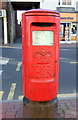
Elizabeth II postbox on Market Place, Driffield
Postbox No. YO25 302.
See Image] for context.
Image: © JThomas
Taken: 6 Aug 2016
0.01 miles
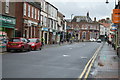
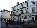
3
Market Place, Driffield
Looking south east showing position of Postbox No. YO25 302.
See Image] for postbox.
Image: © JThomas
Taken: 6 Aug 2016
0.01 miles
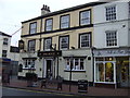
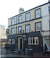
4
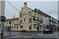
The Buck
Grade II listed. http://www.britishlistedbuildings.co.uk/101309913-buck-inn-and-number-2-adjoining-to-right-driffield
Image: © N Chadwick
Taken: 1 Jan 2017
0.01 miles
6
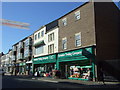
Yorkshire Trading Company, Driffield
On Market Place.
Image: © JThomas
Taken: 6 Aug 2016
0.01 miles
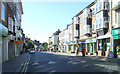
10
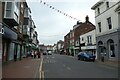
Market Place, Driffield
Looking along the high street in Driffield.
Image: © DS Pugh
Taken: 10 Jul 2021
0.02 miles