IMAGES TAKEN NEAR TO
Easterfield Drive, DRIFFIELD, YO25 5PQ
Introduction
This page details the photographs taken nearby to Easterfield Drive, YO25 5PQ by members of the Geograph project.
The Geograph project started in 2005 with the aim of publishing, organising and preserving representative images for every square kilometre of Great Britain, Ireland and the Isle of Man.

There are currently over 7.5m images from over14,400 individuals and you can help contribute to the project by visiting https://www.geograph.org.uk
Image Map (Loading...)


Getting Data...Please wait
Leaflet Map data © OpenStreetMap
Images are licensed for reuse under creativecommons.org/licenses/by-sa/2.0
Notes
- Clicking on the map will re-center to the selected point.
- The higher the marker number, the further away the image location is from the centre of the postcode.
Image Listing (174 Images Found)
Images are licensed for reuse under creativecommons.org/licenses/by-sa/2.0
Image
Details
Distance
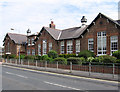
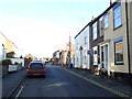
1
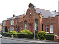
Driffield - Police Station
On Scarborough Road.
Image: © Dave Bevis
Taken: 1 Aug 2011
0.02 miles
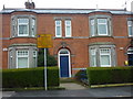
6
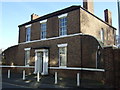
Easterfield House, Driffield
On New Road - now a funeral directors.
Image: © JThomas
Taken: 20 Dec 2014
0.04 miles
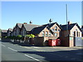
7
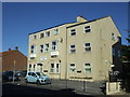
Brunswick Court, Driffield
Flats on New Road.
Image: © JThomas
Taken: 6 Aug 2016
0.05 miles
8
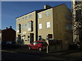
Brunswick Court
Flats on New Road, Driffield.
Image: © JThomas
Taken: 20 Dec 2014
0.05 miles
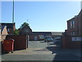
9
New Road, Driffield
Heading north east on National Cycle Route 1.
Image: © JThomas
Taken: 20 Dec 2014
0.06 miles
10
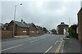
Bridlington Road, Driffield
Looking towards the junction with Wansford Road.
Image: © DS Pugh
Taken: 10 Jul 2021
0.06 miles