IMAGES TAKEN NEAR TO
Easingwood Way, DRIFFIELD, YO25 5PJ
Introduction
This page details the photographs taken nearby to Easingwood Way, YO25 5PJ by members of the Geograph project.
The Geograph project started in 2005 with the aim of publishing, organising and preserving representative images for every square kilometre of Great Britain, Ireland and the Isle of Man.

There are currently over 7.5m images from over14,400 individuals and you can help contribute to the project by visiting https://www.geograph.org.uk
Image Map
Images are licensed for reuse under creativecommons.org/licenses/by-sa/2.0
Notes
- Clicking on the map will re-center to the selected point.
- The higher the marker number, the further away the image location is from the centre of the postcode.
Image Listing (42 Images Found)
Images are licensed for reuse under creativecommons.org/licenses/by-sa/2.0
Image
Details
Distance
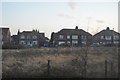
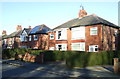
1

Eastern edge of new housing on Meadow Road
A play area to the left to the hedge.
Image: © Martin Dawes
Taken: 24 Nov 2020
0.05 miles
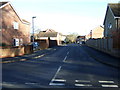
3
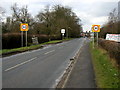
The road into Driffield.
Taken on the Wansford to Driffield road at MR03365718 looking NW.
Image: © Andy Beecroft
Taken: 14 Feb 2006
0.11 miles
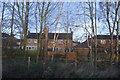

8
Verity Way, Driffield
Off Wansford Road (B1249).
Image: © JThomas
Taken: 20 Dec 2014
0.13 miles
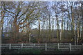
9
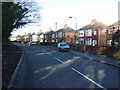
Wansford Road (B1249), Driffield
Heading north west.
Image: © JThomas
Taken: 20 Dec 2014
0.13 miles
