IMAGES TAKEN NEAR TO
Dunns Lane, DRIFFIELD, YO25 5NA
Introduction
This page details the photographs taken nearby to Dunns Lane, YO25 5NA by members of the Geograph project.
The Geograph project started in 2005 with the aim of publishing, organising and preserving representative images for every square kilometre of Great Britain, Ireland and the Isle of Man.

There are currently over 7.5m images from over14,400 individuals and you can help contribute to the project by visiting https://www.geograph.org.uk
Image Map
Images are licensed for reuse under creativecommons.org/licenses/by-sa/2.0
Notes
- Clicking on the map will re-center to the selected point.
- The higher the marker number, the further away the image location is from the centre of the postcode.
Image Listing (212 Images Found)
Images are licensed for reuse under creativecommons.org/licenses/by-sa/2.0
Image
Details
Distance
1
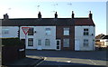
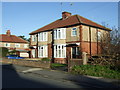
Terraced housing, Wansford Road (B1249), Driffield
Image: © JThomas
Taken: 20 Dec 2014
0.03 miles
2

Driffield Christian Fellowship
On Wansford Road (B1249).
Image: © JThomas
Taken: 20 Dec 2014
0.04 miles

4
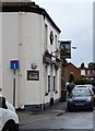
Driffield, Mariners Arms PH
The benchmark is cut into the south west face of the pub. The profile of the cutmark has been painted black.
Image: © Mel Towler
Taken: 28 Mar 2022
0.04 miles
5

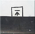
Driffield, Mariners Arms PH
There is a benchmark cut into the south west face of the pub. The profile of the cutmark has been painted black.
Image: © Mel Towler
Taken: 28 Mar 2022
0.04 miles
6
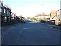
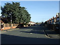
Wansford Road (B1249), Driffield
Heading north west.
Image: © JThomas
Taken: 20 Dec 2014
0.05 miles
9
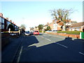
Manorfield Road, Driffield
Off Wansford Road.
Image: © JThomas
Taken: 20 Dec 2014
0.05 miles