IMAGES TAKEN NEAR TO
Ullyott Drive, DRIFFIELD, YO25 5GQ
Introduction
This page details the photographs taken nearby to Ullyott Drive, YO25 5GQ by members of the Geograph project.
The Geograph project started in 2005 with the aim of publishing, organising and preserving representative images for every square kilometre of Great Britain, Ireland and the Isle of Man.

There are currently over 7.5m images from over14,400 individuals and you can help contribute to the project by visiting https://www.geograph.org.uk
Image Map
Images are licensed for reuse under creativecommons.org/licenses/by-sa/2.0
Notes
- Clicking on the map will re-center to the selected point.
- The higher the marker number, the further away the image location is from the centre of the postcode.
Image Listing (16 Images Found)
Images are licensed for reuse under creativecommons.org/licenses/by-sa/2.0
Image
Details
Distance
1
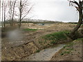
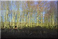
Meadow Stream In the rain
It no longer runs through meadows, shortly to be a new housing estate
Image: © Martin Dawes
Taken: 6 Apr 2016
0.07 miles
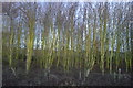
2
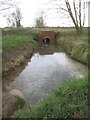
Meadow Stream going under railway line
Taken from Meadow Lane (track) this clear chalk stream goes under the Driffield to Bridlington line
Image: © Martin Dawes
Taken: 24 Nov 2020
0.07 miles

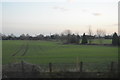
4
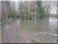
Flooded field and footpath approaching Meadow Gate
The railway is to the left and this footpath takes you to Meadow Gate level crossing
Image: © Martin Dawes
Taken: 6 Apr 2016
0.10 miles

10

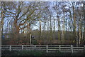
Eastern edge of new housing on Meadow Road
A play area to the left to the hedge.
Image: © Martin Dawes
Taken: 24 Nov 2020
0.18 miles