IMAGES TAKEN NEAR TO
White Avenue, YO25 5FQ
Introduction
This page details the photographs taken nearby to White Avenue, YO25 5FQ by members of the Geograph project.
The Geograph project started in 2005 with the aim of publishing, organising and preserving representative images for every square kilometre of Great Britain, Ireland and the Isle of Man.

There are currently over 7.5m images from over14,400 individuals and you can help contribute to the project by visiting https://www.geograph.org.uk
Image Map
Images are licensed for reuse under creativecommons.org/licenses/by-sa/2.0
Notes
- Clicking on the map will re-center to the selected point.
- The higher the marker number, the further away the image location is from the centre of the postcode.
Image Listing (38 Images Found)
Images are licensed for reuse under creativecommons.org/licenses/by-sa/2.0
Image
Details
Distance
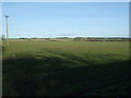
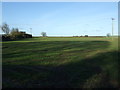
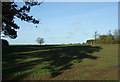
3
Field and hedgerow
North of Bridlington Road.
Image: © JThomas
Taken: 20 Dec 2014
0.12 miles
4
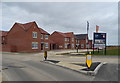
Wolds View
New housing on the edge of Driffield.
Image: © JThomas
Taken: 3 Apr 2020
0.14 miles
5
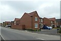
Houses on Berriman Drive
A new housing development on the edge of Driffield.
Image: © DS Pugh
Taken: 10 Jul 2021
0.14 miles
6
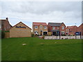
Wolds View
New housing on the edge of Driffield.
Image: © JThomas
Taken: 3 Apr 2020
0.15 miles
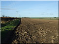
8
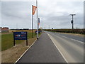
National Cycle Route 1
Heading out of Driffield on Bridlington Road.
Image: © JThomas
Taken: 3 Apr 2020
0.16 miles
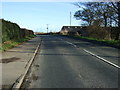
9
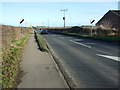
Leaving Driffield
Heading north east on Bridlington Road.
Image: © JThomas
Taken: 20 Dec 2014
0.16 miles