IMAGES TAKEN NEAR TO
East End Cottages, DRIFFIELD, YO25 4SA
Introduction
This page details the photographs taken nearby to East End Cottages, YO25 4SA by members of the Geograph project.
The Geograph project started in 2005 with the aim of publishing, organising and preserving representative images for every square kilometre of Great Britain, Ireland and the Isle of Man.

There are currently over 7.5m images from over14,400 individuals and you can help contribute to the project by visiting https://www.geograph.org.uk
Image Map (Loading...)


Getting Data...Please wait
Leaflet Map data © OpenStreetMap
Images are licensed for reuse under creativecommons.org/licenses/by-sa/2.0
Notes
- Clicking on the map will re-center to the selected point.
- The higher the marker number, the further away the image location is from the centre of the postcode.
Image Listing (18 Images Found)
Images are licensed for reuse under creativecommons.org/licenses/by-sa/2.0
Image
Details
Distance
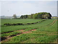
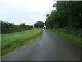
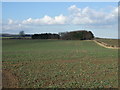
2
Leaving Kilham
Heading north east on the old Roman Road.
Image: © JThomas
Taken: 21 Feb 2015
0.03 miles
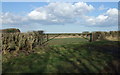
3
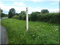
Passing place marker on Woldgate, east of Kilham
In some parts of the Yorkshire Wolds passing places on single-track roads are marked by a white wooden post with the letter P in black.
Image: © Christine Johnstone
Taken: 6 Jul 2020
0.06 miles
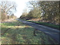
4
Woldgate, heading east out of Kilham
The route of the Roman road from York to Bridlington. 'Gate'in this context comes from 'gatta', the Viking word for street or road. A civil parish boundary runs down the road here, between Kilham [left/north] and Harpham [right/south].
Image: © Christine Johnstone
Taken: 6 Jul 2020
0.07 miles
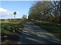
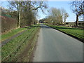
6
Woldgate
Looking east along the old Roman Road.
Image: © JThomas
Taken: 21 Feb 2015
0.13 miles
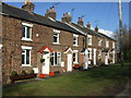
9
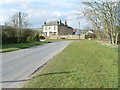
Mount Pleasant, Kilham, East Yorkshire
Mount Pleasant is the name of the road, and behind the hedge to the left is Mount Pleasant Farm complete with noisy geese. The house is Laurel Bank, and the seat provides welcome rest for walkers' legs.
Image: © Peter Church
Taken: 9 Mar 2008
0.20 miles