IMAGES TAKEN NEAR TO
Cherry Way, DRIFFIELD, YO25 4PA
Introduction
This page details the photographs taken nearby to Cherry Way, YO25 4PA by members of the Geograph project.
The Geograph project started in 2005 with the aim of publishing, organising and preserving representative images for every square kilometre of Great Britain, Ireland and the Isle of Man.

There are currently over 7.5m images from over14,400 individuals and you can help contribute to the project by visiting https://www.geograph.org.uk
Image Map
Images are licensed for reuse under creativecommons.org/licenses/by-sa/2.0
Notes
- Clicking on the map will re-center to the selected point.
- The higher the marker number, the further away the image location is from the centre of the postcode.
Image Listing (134 Images Found)
Images are licensed for reuse under creativecommons.org/licenses/by-sa/2.0
Image
Details
Distance
7
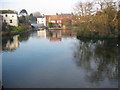
Nafferton Pond
Looking north to the pond which reaches to the north edge of the grid square.
Image: © Stephen Horncastle
Taken: 15 Jan 2006
0.10 miles
9
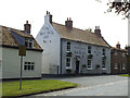
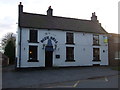
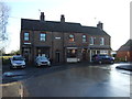
The Blue Bell, Nafferton
An 18th century public house, listed grade 2 (list entry 1309752).
Image: © Stephen Craven
Taken: 8 Jul 2017
0.11 miles