IMAGES TAKEN NEAR TO
Main Street, DRIFFIELD, YO25 4NG
Introduction
This page details the photographs taken nearby to Main Street, YO25 4NG by members of the Geograph project.
The Geograph project started in 2005 with the aim of publishing, organising and preserving representative images for every square kilometre of Great Britain, Ireland and the Isle of Man.

There are currently over 7.5m images from over14,400 individuals and you can help contribute to the project by visiting https://www.geograph.org.uk
Image Map (Loading...)


Getting Data...Please wait
Leaflet Map data © OpenStreetMap
Images are licensed for reuse under creativecommons.org/licenses/by-sa/2.0
Notes
- Clicking on the map will re-center to the selected point.
- The higher the marker number, the further away the image location is from the centre of the postcode.
Image Listing (159 Images Found)
Images are licensed for reuse under creativecommons.org/licenses/by-sa/2.0
Image
Details
Distance
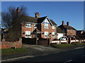
1
The Old Police Station, Main Road, Burton Agnes
Image: © Ian S
Taken: 4 Dec 2019
0.03 miles
2
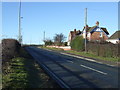
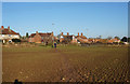
Main Street (A614), Burton Agnes
Heading south west.
Image: © JThomas
Taken: 21 Feb 2015
0.03 miles
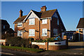
3
Former police house, Burton Agnes
On Main Street (A614).
Image: © JThomas
Taken: 21 Feb 2015
0.04 miles
4
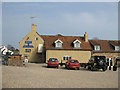
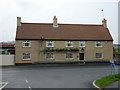
The Blue Bell Inn
Hotel and brasserie, Burton Agnes.
Image: © Pauline E
Taken: 23 Mar 2012
0.05 miles
6
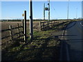
Footpath off Main Street (A614), Burton Agnes
Image: © JThomas
Taken: 21 Feb 2015
0.07 miles
8
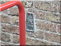
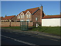
Ordnance Survey Flush Bracket S6565
This bracket can be found on the wall of the school.
For more detail see : http://www.bench-marks.org.uk/bm11500
Image: © Peter Wood
Taken: 28 Jul 2012
0.08 miles
9
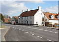
The Blue Bell, Burton Agnes
This public house seems to be undergoing renovation.
Image: © Peter Church
Taken: 9 Mar 2008
0.09 miles