IMAGES TAKEN NEAR TO
Rudston, DRIFFIELD, YO25 4DW
Introduction
This page details the photographs taken nearby to YO25 4DW by members of the Geograph project.
The Geograph project started in 2005 with the aim of publishing, organising and preserving representative images for every square kilometre of Great Britain, Ireland and the Isle of Man.

There are currently over 7.5m images from over14,400 individuals and you can help contribute to the project by visiting https://www.geograph.org.uk
Image Map
Images are licensed for reuse under creativecommons.org/licenses/by-sa/2.0
Notes
- Clicking on the map will re-center to the selected point.
- The higher the marker number, the further away the image location is from the centre of the postcode.
Image Listing (12 Images Found)
Images are licensed for reuse under creativecommons.org/licenses/by-sa/2.0
Image
Details
Distance
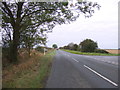
4
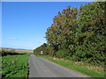
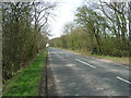
Road to Thwing
Looking north from near the road junction with the B1253.
Image: © Stephen Horncastle
Taken: 9 Oct 2006
0.11 miles
5
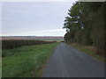
Minor road towards Thwing
Heading north from the B1253.
Image: © JThomas
Taken: 8 Oct 2016
0.12 miles
6
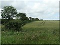
Wheatfield west of Dicky Smith's Plantation
On the north side of High Street [B1253].
Image: © Christine Johnstone
Taken: 8 Jul 2020
0.18 miles
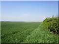
7
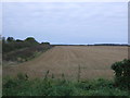
Stubble field beside the B1253
Looking west.
Image: © JThomas
Taken: 8 Oct 2016
0.18 miles
8
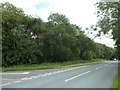
Dicky Smith's Plantation, near Rudston Grange
On the north side of High Street [B1253].
Image: © Christine Johnstone
Taken: 8 Jul 2020
0.19 miles
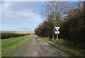
9
Road junction on High Street (B1253)
Looking west.
Image: © JThomas
Taken: 8 Oct 2016
0.20 miles