IMAGES TAKEN NEAR TO
Maltongate, DRIFFIELD, YO25 3TW
Introduction
This page details the photographs taken nearby to Maltongate, YO25 3TW by members of the Geograph project.
The Geograph project started in 2005 with the aim of publishing, organising and preserving representative images for every square kilometre of Great Britain, Ireland and the Isle of Man.

There are currently over 7.5m images from over14,400 individuals and you can help contribute to the project by visiting https://www.geograph.org.uk
Image Map (Loading...)


Getting Data...Please wait
Leaflet Map data © OpenStreetMap
Images are licensed for reuse under creativecommons.org/licenses/by-sa/2.0
Notes
- Clicking on the map will re-center to the selected point.
- The higher the marker number, the further away the image location is from the centre of the postcode.
Image Listing (101 Images Found)
Images are licensed for reuse under creativecommons.org/licenses/by-sa/2.0
Image
Details
Distance
1
Very short path
Links Church Lane with Sledmere Road.
Image: © Jonathan Thacker
Taken: 24 Mar 2016
0.02 miles
2
The lower part of Church Lane, Langtoft
Image: © Jonathan Thacker
Taken: 24 Mar 2016
0.03 miles
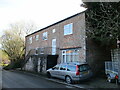
3
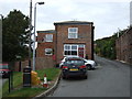
House on Church Lane, Langtoft
Showing position of Postbox No. YO25 373.
See Image] for postbox.
Image: © JThomas
Taken: 8 Oct 2016
0.03 miles
4
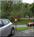
Elizabeth II postbox, Langtoft
Image: © JThomas
Taken: 8 Oct 2016
0.03 miles
5
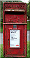
Close up, Elizabeth II postbox, Langtoft
Postbox No. YO25 373.
See Image] for wider view.
Image: © JThomas
Taken: 8 Oct 2016
0.03 miles
7
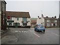
Junction of Sledmere Road and Scarborough Road
Scarborough road is the main north/south road through the village, Ship Inn across the road
Image: © Martin Dawes
Taken: 8 Nov 2011
0.04 miles
8
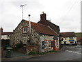
The Fire Station
Not a fire station with fire engines but The Fire Station selling fuel suitable for domestic fires.
The building is one of many in Langtoft which uses clunch (chalk) in its construction.
Image: © Jonathan Thacker
Taken: 24 Mar 2016
0.04 miles
9
Former Primitive Methodist Chapel and School. Cottam Lane
The plaque above the white door reads, Primitive Methodist Chapel built 1839. At the far end of the building between the upstairs windows is a plaque reading, Primitive Methodist School with an indistinct date which could be 1848
Image: © Martin Dawes
Taken: 10 Feb 2022
0.04 miles
10
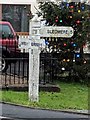
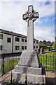
Direction Sign ? Signpost on the B1249 Front Street in Langtoft
Located next to the war memorial on the southwest side of the junction of the B1249 Front Street and Sledmere Road in Langtoft parish. 3 arms but no finial.
Milestone Society National ID: YE_TA0066
Image: © A Wagstaff-Weston
Taken: 26 Dec 2018
0.04 miles