IMAGES TAKEN NEAR TO
Spellowgate, DRIFFIELD, YO25 3AA
Introduction
This page details the photographs taken nearby to Spellowgate, YO25 3AA by members of the Geograph project.
The Geograph project started in 2005 with the aim of publishing, organising and preserving representative images for every square kilometre of Great Britain, Ireland and the Isle of Man.

There are currently over 7.5m images from over14,400 individuals and you can help contribute to the project by visiting https://www.geograph.org.uk
Image Map
Images are licensed for reuse under creativecommons.org/licenses/by-sa/2.0
Notes
- Clicking on the map will re-center to the selected point.
- The higher the marker number, the further away the image location is from the centre of the postcode.
Image Listing (13 Images Found)
Images are licensed for reuse under creativecommons.org/licenses/by-sa/2.0
Image
Details
Distance
1
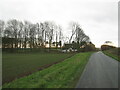
House and covered reservoir on Spellowgate
The grassed top of the reservoir can be seen through the trees to the left of the house
Image: © Martin Dawes
Taken: 24 Nov 2020
0.00 miles
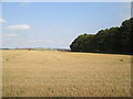
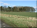
3
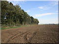
Field and woodland, West Hills
Off Spellowgate.
Image: © JThomas
Taken: 21 Feb 2015
0.05 miles
4
Stubble field and trees around covered Reservoir
From Spellergate on Elmswell Wold
Image: © Martin Dawes
Taken: 10 Sep 2014
0.06 miles
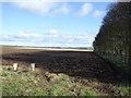
5
Woodland around reservoir
Off Driffield Spellowgate.
Image: © JThomas
Taken: 21 Feb 2015
0.07 miles
7
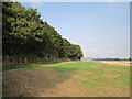
Windbreak trees around covered reservoir
From Spellowgate
Image: © Martin Dawes
Taken: 10 Sep 2014
0.07 miles
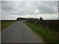
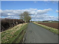
8
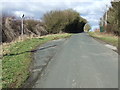
Passing place on Driffield Spellowgate
Heading north .
Image: © JThomas
Taken: 21 Feb 2015
0.07 miles
9
Trees by a reservoir on Elmswell Wold
Image: © Jonathan Thacker
Taken: 19 Oct 2018
0.08 miles
10

NW Of Driffield
This grid square is all farmland.
Image: © Stephen Horncastle
Taken: 3 Feb 2007
0.09 miles