IMAGES TAKEN NEAR TO
Clementhorpe, YORK, YO23 1PN
Introduction
This page details the photographs taken nearby to Clementhorpe, YO23 1PN by members of the Geograph project.
The Geograph project started in 2005 with the aim of publishing, organising and preserving representative images for every square kilometre of Great Britain, Ireland and the Isle of Man.

There are currently over 7.5m images from over14,400 individuals and you can help contribute to the project by visiting https://www.geograph.org.uk
Image Map
Images are licensed for reuse under creativecommons.org/licenses/by-sa/2.0
Notes
- Clicking on the map will re-center to the selected point.
- The higher the marker number, the further away the image location is from the centre of the postcode.
Image Listing (1145 Images Found)
Images are licensed for reuse under creativecommons.org/licenses/by-sa/2.0
Image
Details
Distance
1
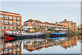
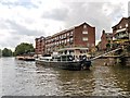
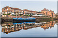
The Postern
Part of a housing development of 1979, otherwise known as Bishops Wharf, designed by the York firm Crease Edmonds Strickland (now Crease Strickland Parkins). It is situated between Bishopsgate Street and Clementhorpe, with this length on Terry Avenue overlooking the River Ouse. The southern part of the site was originally occupied by confectioners Joseph Terry and Sons, who had bought the area in 1862. It had previously been the site of the Clementhorpe Brewery, before becoming part of ironworks of Messrs Calvert & Son, ironfounders, who had become bankrupt in 1862. The site was the centre of Terry's confectionery business, making use of the river for raw materials and fuel, until they moved to their purpose built works on Bishopthorpe Road in 1926, but they then continued to use it after the move until the 1970s. The northern part of the site was previously occupied by a fertiliser factory (old maps mark it as a "chemical manure works") run by a firm named Richardsons. It closed in 1973 following the firm's takeover by Hargreaves Fertilisers Ltd.
On the far left is part of Waterfront House (see Image).
Moored on the river on the left is a converted Dutch barge named Morgenster and on the right is another converted barge, the MV Till.
Image: © Ian Capper
Taken: 5 Feb 2023
0.02 miles
3
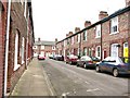
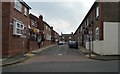
Colenso Street
Street of modest terraced houses in the Clementhorpe area of the city. The brick built terraces in this area date from around 1900.
Image: © Gordon Hatton
Taken: 26 Feb 2009
0.02 miles
4
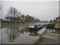
York, moorings
Permanent moorings on River Ouse next to Terry Avenue; a slight morning mist on the river.
Image: © Mike Faherty
Taken: 19 Feb 2018
0.02 miles
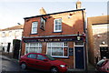
5
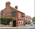
The Slip Inn
Victorian town pub situated on Clementhorpe close to the river.
Image: © Gordon Hatton
Taken: 26 Feb 2009
0.02 miles
6
River Ouse, Downstream of Skeldergate Bridge
Image: © David Dixon
Taken: 29 Jun 2014
0.02 miles
7
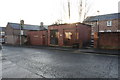
Electricity Sub Station Clementhorpe
Image: © Michael Jagger
Taken: 13 Dec 2009
0.02 miles
8
The Postern
Looking down the River Ouse from Skeldergate Bridge in early morning sunshine, with the 1979 housing development The Postern on the right. Otherwise known as Bishops Wharf, it was designed by the York firm Crease Edmonds Strickland (now Crease Strickland Parkins). It is situated between Bishopsgate Street and Clementhorpe, with this length on Terry Avenue overlooking the River Ouse. The southern part of the site was originally occupied by confectioners Joseph Terry and Sons, who had bought the area in 1862. It had previously been the site of the Clementhorpe Brewery, before becoming part of ironworks of Messrs Calvert & Son, ironfounders, who had become bankrupt in 1862. The site was the centre of Terry's confectionery business, making use of the river for raw materials and fuel, until they moved to their purpose built works on Bishopthorpe Road in 1926, but they then continued to use it after the move until the 1970s. The northern part of the site was previously occupied by a fertiliser factory (old maps mark it as a "chemical manure works") run by a firm named Richardsons. It closed in 1973 following the firm's takeover by Hargreaves Fertilisers Ltd.
Beyond are Waterfront House and Dukes Wharf (see Image).
A large skein of geese can be seen flying over.
Image: © Ian Capper
Taken: 5 Feb 2023
0.02 miles
10
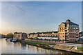
The Postern
Part of a housing development of 1979, otherwise known as Bishops Wharf, designed by the York firm Crease Edmonds Strickland (now Crease Strickland Parkins). It is situated between Bishopsgate Street and Clementhorpe, with this length on Terry Avenue overlooking the River Ouse. The southern part of the site was originally occupied by confectioners Joseph Terry and Sons, who had bought the area in 1862. It had previously been the site of the Clementhorpe Brewery, before becoming part of ironworks of Messrs Calvert & Son, ironfounders, who had become bankrupt in 1862. The site was the centre of Terry's confectionery business, making use of the river for raw materials and fuel, until they moved to their purpose built works on Bishopthorpe Road in 1926, but they then continued to use it after the move until the 1970s. The northern part of the site was previously occupied by a fertiliser factory (old maps mark it as a "chemical manure works") run by a firm named Richardsons. It closed in 1973 following the firm's takeover by Hargreaves Fertilisers Ltd.
Moored on the river is a converted barge, the MV Till.
Image: © Ian Capper
Taken: 5 Feb 2023
0.02 miles