The Postern
Introduction
The photograph on this page of The Postern by Ian Capper as part of the Geograph project.
The Geograph project started in 2005 with the aim of publishing, organising and preserving representative images for every square kilometre of Great Britain, Ireland and the Isle of Man.

There are currently over 7.5m images from over 14,400 individuals and you can help contribute to the project by visiting https://www.geograph.org.uk
The Postern
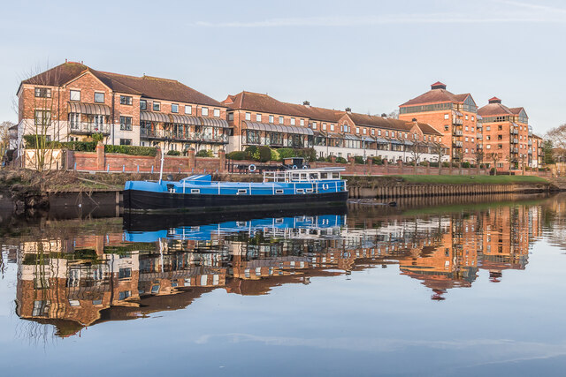
Image: © Ian Capper Taken: 5 Feb 2023
Part of a housing development of 1979, otherwise known as Bishops Wharf, designed by the York firm Crease Edmonds Strickland (now Crease Strickland Parkins). It is situated between Bishopsgate Street and Clementhorpe, with this length on Terry Avenue overlooking the River Ouse. The southern part of the site was originally occupied by confectioners Joseph Terry and Sons, who had bought the area in 1862. It had previously been the site of the Clementhorpe Brewery, before becoming part of ironworks of Messrs Calvert & Son, ironfounders, who had become bankrupt in 1862. The site was the centre of Terry's confectionery business, making use of the river for raw materials and fuel, until they moved to their purpose built works on Bishopthorpe Road in 1926, but they then continued to use it after the move until the 1970s. The northern part of the site was previously occupied by a fertiliser factory (old maps mark it as a "chemical manure works") run by a firm named Richardsons. It closed in 1973 following the firm's takeover by Hargreaves Fertilisers Ltd. Moored on the river is a converted barge, the MV Till.
Images are licensed for reuse under creativecommons.org/licenses/by-sa/2.0
Image Location
Latitude
53.95301
Longitude
-1.081114