IMAGES TAKEN NEAR TO
Swann Street, YORK, YO23 1AF
Introduction
This page details the photographs taken nearby to Swann Street, YO23 1AF by members of the Geograph project.
The Geograph project started in 2005 with the aim of publishing, organising and preserving representative images for every square kilometre of Great Britain, Ireland and the Isle of Man.

There are currently over 7.5m images from over14,400 individuals and you can help contribute to the project by visiting https://www.geograph.org.uk
Image Map
Images are licensed for reuse under creativecommons.org/licenses/by-sa/2.0
Notes
- Clicking on the map will re-center to the selected point.
- The higher the marker number, the further away the image location is from the centre of the postcode.
Image Listing (868 Images Found)
Images are licensed for reuse under creativecommons.org/licenses/by-sa/2.0
Image
Details
Distance
1
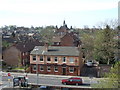
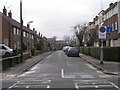
Trafalgar Bay pub on Nunnery Way
Pub on Inner Ring Road seen from city wall. Nunthorpe Road school in the background.
Image: © Stanley Howe
Taken: 19 Apr 2007
0.01 miles
3
Swann Street seen from the city walls, York
Image: © habiloid
Taken: 31 Aug 2022
0.04 miles
4
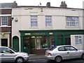
Sheridan's Hairdressing Salon - Nunnery Lane
Image: © Betty Longbottom
Taken: 27 Feb 2010
0.04 miles
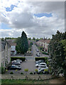
6
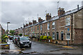
Dale Street
c.1890s/1900s terraced housing. The houses in the background are much later, being part of the post Second World War redevelopment of some of the streets east of there. Although where they stand was initially developed before the section in the foreground, being shown on the 1892 25 inch map whereas this nearer area is still shown as what would appear to be gardens, the 1941 edition maps marks the far area without any housing suggesting redevelopment had been planned but then interrupted by the war.
Image: © Ian Capper
Taken: 21 May 2021
0.04 miles

8

Public toilets, Nunnery Lane, York
Walk past this most mornings on my way to the train station, and have noticed a wonderfully sweet smell - then noticed that the Council has planted lots of honeysuckle around the toilets - genius idea
Image: © hayley green
Taken: 15 Jul 2010
0.05 miles
9

Dale Street
c.1890s/1900s terraced housing. The houses in the background are earlier, being shown on the 1892 25 inch map whereas this nearer area is still shown as what would appear to be gardens.
Image: © Ian Capper
Taken: 21 May 2021
0.05 miles
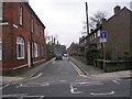
10
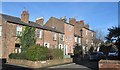
Dove Street
A curious little street with a hotchpotch of housing styles and ages. The street is outside of the city wall, but is almost surrounded by uninspiring municipal housing and flats of the fifties and sixties.
Image: © Gordon Hatton
Taken: 16 Feb 2016
0.05 miles