IMAGES TAKEN NEAR TO
Beckhole, WHITBY, YO22 5LE
Introduction
This page details the photographs taken nearby to YO22 5LE by members of the Geograph project.
The Geograph project started in 2005 with the aim of publishing, organising and preserving representative images for every square kilometre of Great Britain, Ireland and the Isle of Man.

There are currently over 7.5m images from over14,400 individuals and you can help contribute to the project by visiting https://www.geograph.org.uk
Image Map
Images are licensed for reuse under creativecommons.org/licenses/by-sa/2.0
Notes
- Clicking on the map will re-center to the selected point.
- The higher the marker number, the further away the image location is from the centre of the postcode.
Image Listing (126 Images Found)
Images are licensed for reuse under creativecommons.org/licenses/by-sa/2.0
Image
Details
Distance

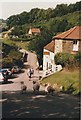
2
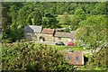
Beck Hole
Looking down to the hamlet from close to the railway bridge. The building immediately behind the two cars, and the land beyond, has been the site of a farm since at least the seventeenth century.
Image: © David Marsden
Taken: 3 Jun 2007
0.01 miles
3

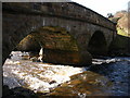
Two arch bridge, Beck Hole
Over the Eller Beck.
Image: © Chris Allen
Taken: 23 Jul 2010
0.02 miles
4
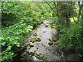
Beck and Bridge
Photograph was tahen from a narrow path by the pub and shop. Looking downstream.
Image: © SMJ
Taken: 30 Mar 2008
0.02 miles
5

Eller Beck from the bridge at Beck Hole
Image: © David Martin
Taken: 21 Apr 2017
0.02 miles
6
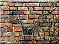
Detail of outbuilding
Detail of outbuilding made from recycled fire bricks from the blast furnaces that were built in the village in the middle 19c. See Image]
Image: © Mick Garratt
Taken: 16 Mar 2016
0.02 miles
8

Stone bridge at Beck Hole
Single track over Eller Beck. Beyond is the Birch Hall Inn and the K6 phonebox.
Image: © Pauline E
Taken: 29 Sep 2014
0.02 miles
9
Birch Hall Inn, Beck Hole
Perhaps the sheep were thirsty and wanting a drink!
Image: © Richard Sutcliffe
Taken: Unknown
0.03 miles
10
Site of termination of Beckhole branch from Grosmont
View SW, to the end of the line, which had until 1865 been the upper end of an incline worked by horses from the Grosmont - Pickering section of the 1836 Whitby & Pickering Railway. In 1865 the NER built a four-mile deviation from Grosmont to replace this incline, but the stub, running to a proper station 'Beckhole', 200 yards further back (off this view), to which a passenger service was run in summer only, 1908-1914; goods was worked until 7/30, when floods demolished a bridge, although they continued for a short distance from Grosmont Branch Junction until 1952.
Image: © Ben Brooksbank
Taken: 9 Jun 1988
0.03 miles