IMAGES TAKEN NEAR TO
Esk Valley, WHITBY, YO22 5BG
Introduction
This page details the photographs taken nearby to Esk Valley, YO22 5BG by members of the Geograph project.
The Geograph project started in 2005 with the aim of publishing, organising and preserving representative images for every square kilometre of Great Britain, Ireland and the Isle of Man.

There are currently over 7.5m images from over14,400 individuals and you can help contribute to the project by visiting https://www.geograph.org.uk
Image Map
Images are licensed for reuse under creativecommons.org/licenses/by-sa/2.0
Notes
- Clicking on the map will re-center to the selected point.
- The higher the marker number, the further away the image location is from the centre of the postcode.
Image Listing (62 Images Found)
Images are licensed for reuse under creativecommons.org/licenses/by-sa/2.0
Image
Details
Distance
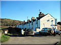
1
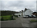
Long terrace of cottages from Rail Trail
At the far end of the cottages is the railway line from Grosmont up to Goathland
Image: © Martin Dawes
Taken: 26 Apr 2022
0.01 miles
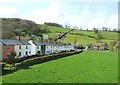
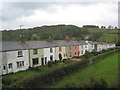
2
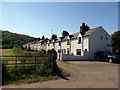
Esk Valley
The hamlet of Esk Valley started life in 1860 as a row of four cottages, built for workers at the ironstone mines to the north. Beneath the living quarters were a blacksmiths’ shop, a joiner’s, a tiny office and a washroom. A few years later, as the workforce expanded, a terrace of 24 cottages was built on the other side of the former railway track (now 'Rail Trail' footpath). Esk Valley relied on the railway to bring coal, food and provisions until 1951, when the community raised enough money to construct the steep road leading down to the hamlet.
Image: © Andrew Curtis
Taken: 27 Jun 2018
0.01 miles
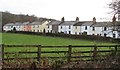
3
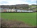
Cottages at Esk Valley, from the north-east
Built for ironstone miners, Lying between the original and the current railway lines between Grosmont and Goathland.
Image: © Christine Johnstone
Taken: 14 Apr 2015
0.01 miles
4
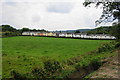
Cottages at Esk Valley
Built in a long straight line for the benefit of ironstone miners.
Image: © Bill Boaden
Taken: 3 Sep 2014
0.01 miles
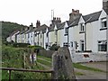
6
Esk Valley terrace
There appears to be several photos of this terrace of Victorian cottages submitted for this square, and whilst most contributors suggest that the housing was for iron ore miners, at least one suggests that they may have been built as railway workers cottages.
Looking at old 6" maps of the area, the 1848 survey shows a nearby ironstone mine, but no cottages, whilst by 1892 the ironstone mines are disused, but the cottages are shown. Another factor is the expansion of the nearby whinstone quarries, which exploited the Cleveland Dyke running right across the valley at this point. I might be inclined to think that these were quarrymen's cottages, but as Mick Garrett suggests iron ore miners, I'll go with that.
Image: © Gordon Hatton
Taken: 18 Dec 2016
0.01 miles
7
Railway Cottages in the Esk Valley
For more information about this line of cottages, see Image
Image: © Mary and Angus Hogg
Taken: 22 Apr 2012
0.01 miles
8
Esk Valley cottages
Built in the 19th century for the local iron works
Image: © David Smith
Taken: 16 Jun 2015
0.01 miles
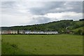
10
Cottages at Esk Valley
In 2009 the hamlet celebrated its 150th year of the existence. The hamlet's name relates to the existence of the formation of The Esk Valley Iron Company, around 1859, even though the hamlet is situated in the Murk Esk Valley. A 200ft deep shaft was sunk to reach the ironstone, which was worked on a small scale for around a decade.
By the 1870s, the lease to extract ore had been transferred to the South Cleveland Ironworks Limited who built 25 cottages, (shown in the picture), and a manager's house. Alas, the mine was not run at a profit and it finally closed in 1875. Many of the miners then went on to work in the local whinstone mines.
Image: © Pauline E
Taken: 15 Sep 2011
0.02 miles