IMAGES TAKEN NEAR TO
Elbow Terrace, WHITBY, YO22 4HF
Introduction
This page details the photographs taken nearby to Elbow Terrace, YO22 4HF by members of the Geograph project.
The Geograph project started in 2005 with the aim of publishing, organising and preserving representative images for every square kilometre of Great Britain, Ireland and the Isle of Man.

There are currently over 7.5m images from over14,400 individuals and you can help contribute to the project by visiting https://www.geograph.org.uk
Image Map
Images are licensed for reuse under creativecommons.org/licenses/by-sa/2.0
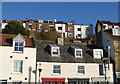
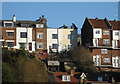
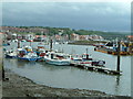
Notes
- Clicking on the map will re-center to the selected point.
- The higher the marker number, the further away the image location is from the centre of the postcode.
Image Listing (2107 Images Found)
Images are licensed for reuse under creativecommons.org/licenses/by-sa/2.0
Image
Details
Distance
2
Merchant Seamen's Hospital Houses
Merchant seamens hospital houses Whitby, North Yorkshire.
Image: © Keith Evans
Taken: 27 May 2009
0.01 miles
3
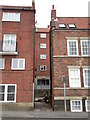
Gap between the houses
Church Street, Whitby
Image: © Jonathan Thacker
Taken: 8 May 2015
0.02 miles
4
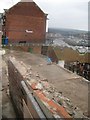
Demolition begins on Aelfleda Terrace
Following a landslip last Tuesday, some of the houses have been declared unsafe and demolition has begun. Due to the precarious nature of the job, it is being undertaken by hand, brick by brick. At this point, the dormers and roofs have been removed and work is underway on the chimney stack. For news story, see http://www.bbc.co.uk/news/uk-england-york-north-yorkshire-20565525
Image: © Pauline E
Taken: 2 Dec 2012
0.02 miles
5
Demolition, by hand
Following a landslip last Tuesday, some of the houses on Aelfleda Terrace have been declared unsafe and demolition has begun. Due to the precarious nature of the job, it is being undertaken by hand, brick by brick. At this point, the dormers and roofs have been removed and work is underway on the chimney stack. The gardens, fences and patios are slipping down the hillside towards the building below.
For news story, see http://www.bbc.co.uk/news/uk-england-york-north-yorkshire-20565525
Image: © Pauline E
Taken: 2 Dec 2012
0.02 miles
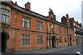
6
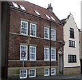
Campion Bank House, 51 Church Street
Originally the banking house of Robert and Margaret Campion, founded in 1800, this grade II listed building comprises 2 storeys in brick and a basement in stone. The pantile roof has been replaced.
51a, to the right of picture, is a grade II listed building of C18 origin, comprising 3 storeys with a rough rendered Dutch gable to the road.
Image: © Mike Kirby
Taken: 7 Jul 2009
0.02 miles
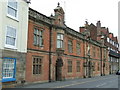
7
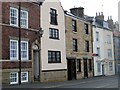
49-49a Church Street
Centre right of picture:- An early C19, grade II listed building comprising 3 storeys in ashlar stone, under a Welsh slate roof with a wood eaves cornice.
Image: © Mike Kirby
Taken: 7 Jul 2009
0.02 miles
8
Where old meets new
This view was taken from the old side of Whitby looking towards the new houses and marina on the left.
Image: © Jill Everington
Taken: 14 Jun 2005
0.03 miles
9
Aelfleda Terrace, following demolition #2
A landslide occurred immediately in front of Aelfleda Terrace on 27th November 2012, following a prolonged period of heavy rain. The 150-year-old former jetworkers’ cottages were very quickly demolished afterwards, to prevent them from crashing down on properties below.
Hundreds of years of history gone forever. See Image and Image
Image: © Mike Kirby
Taken: 10 Feb 2013
0.03 miles
10
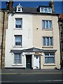
No?s 47 & 48 Church Street
An early C19 grade II listed building comprising 3 storeys under a Welsh slate roof. Note that the doors are under a single cornice, with a central pediment, indicating that this was once a single residence.
Image: © Mike Kirby
Taken: 8 Jul 2009
0.03 miles