IMAGES TAKEN NEAR TO
The Rise, WHITBY, YO22 4ES
Introduction
This page details the photographs taken nearby to The Rise, YO22 4ES by members of the Geograph project.
The Geograph project started in 2005 with the aim of publishing, organising and preserving representative images for every square kilometre of Great Britain, Ireland and the Isle of Man.

There are currently over 7.5m images from over14,400 individuals and you can help contribute to the project by visiting https://www.geograph.org.uk
Image Map
Images are licensed for reuse under creativecommons.org/licenses/by-sa/2.0
Notes
- Clicking on the map will re-center to the selected point.
- The higher the marker number, the further away the image location is from the centre of the postcode.
Image Listing (331 Images Found)
Images are licensed for reuse under creativecommons.org/licenses/by-sa/2.0
Image
Details
Distance
1
St Hilda's Business Centre, The Ropery (2)
Front entrance.
Image: © Mike Kirby
Taken: 8 Jul 2010
0.05 miles
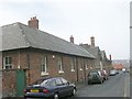
2
St Hilda's Business Centre, The Ropery (1)
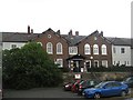
The first Whitby workhouse was built in 1726-7 on Church Street. In 1793-4, a new workhouse was erected off Green Lane. Being located near Boulby's ropery, the site became known as The Ropery. The new building was L-shaped in layout. Whitby Poor Law Union was formed in 1837 and took over the existing workhouse in that year. In 1860, it was enlarged forming a large U-shape. An entrance block was added at the south, and a school was also erected at the rear of the workhouse. After the inauguration of the NHS in 1948, the former workhouse became St Hilda's Hospital and provided geriatric care. St Hilda's closed in 1978 and the surviving buildings are now occupied by small business units.
It is a grade II listed building. LBS Number: 437108
Image: © Mike Kirby
Taken: 8 Jul 2010
0.05 miles
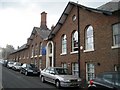
3
St Hilda's Hospital
The history of this building is varied.
From https://historicengland.org.uk/services-skills/education/educational-images/st-hildas-hospital-whitby-7208
"This building was originally the Whitby Workhouse. It was also known as the Ropery and later Whitby Union Workhouse. It was built between 1793 and 1794. It replaced an earlier parish workhouse of 1726-7 on Church Street. In 1837 it became a Union workhouse when it was taken over by the newly created Whitby Poor Law Union. It was enlarged in 1860 to designs by J B and W Atkinson and the additions, including an infirmary, made the building into a U-shape. In 1930, it became a Public Assistance Institution. In 1948, it became part of the National Health Service and was renamed St Hilda's Hospital."
The hospital closed in 1978 on the opening of Whitby Hospital. The buildings were converted to small business units and is now known as St Hilda's Business Centre. Listed, grade II, with details at: https://www.historicengland.org.uk/listing/the-list/list-entry/1253831
Image: © Michael Dibb
Taken: 17 Sep 2017
0.06 miles
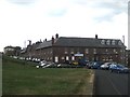
4
St Hilda's Business Centre, The Ropery (3)
Rear entrance. A later addition which mirrors the main entrance.
Image: © Mike Kirby
Taken: 8 Jul 2010
0.06 miles
5
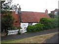
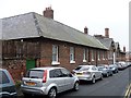
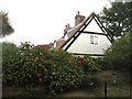
White Cottages, No's 3 & 4, The Ropery
A grade II listed 2 storey cottage displaying a modern plaque which reads:- White Cottages AD 1595.
LBS Number: 326720. (Shown as being in Church Street).
Image: © Mike Kirby
Taken: 8 Jul 2010
0.06 miles
6
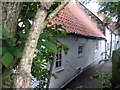
White Cottages, Nos 1 & 2, The Ropery (1)
A grade II listed single storey rendered cottage of probably C17 origin or before, largely hidden from view by trees and hedges.
LBS Number: 326719. (Shown as being on Church Street).
Image: © Mike Kirby
Taken: 8 Jul 2010
0.06 miles
8
White Cottages, Nos 1 & 2, The Ropery (2)
A grade II listed single storey rendered cottage of probably C17 origin or before. Exposed timbers in the gable end of No 1.
LBS Number: 326719. (Shown as being on Church Street).
Image: © Mike Kirby
Taken: 8 Jul 2010
0.06 miles
9
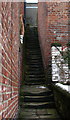
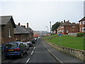
Whitby Steps
Leading from Church Street to Studley Terrace.
Image: © David Rogers
Taken: 22 Feb 2010
0.07 miles