IMAGES TAKEN NEAR TO
YO2 1ZS
Introduction
This page details the photographs taken nearby to YO2 1ZS by members of the Geograph project.
The Geograph project started in 2005 with the aim of publishing, organising and preserving representative images for every square kilometre of Great Britain, Ireland and the Isle of Man.

There are currently over 7.5m images from over14,400 individuals and you can help contribute to the project by visiting https://www.geograph.org.uk
Image Map
Images are licensed for reuse under creativecommons.org/licenses/by-sa/2.0
Notes
- Clicking on the map will re-center to the selected point.
- The higher the marker number, the further away the image location is from the centre of the postcode.
Image Listing (9 Images Found)
Images are licensed for reuse under creativecommons.org/licenses/by-sa/2.0
Image
Details
Distance
1
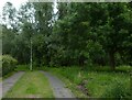
Path in Fishponds Wood
Looking along a path between Danebury Drive and Woodlea Avenue.
Image: © DS Pugh
Taken: 1 Jul 2021
0.14 miles
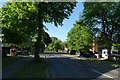
2
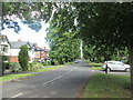
End of Knapton Lane
Limes stand along Knapton Lane near Acomb.
Image: © DS Pugh
Taken: 12 May 2007
0.17 miles
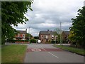
3
Over Ostman Road
Looking onto Viking Road from Jorvik Close.
Image: © DS Pugh
Taken: 1 Jul 2021
0.20 miles
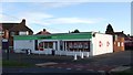
5
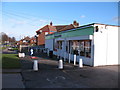
Co-op store, Beckfield Lane
Small co-op store on the western edge of York.
Image: © Gordon Hatton
Taken: 25 Nov 2009
0.23 miles
7
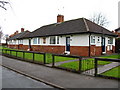
NER Cottage Homes
Dating from 1927 along Woodlea Avenue, Acomb.
Image: © David Rogers
Taken: 2 Feb 2010
0.23 miles
8
Jorvik Close
Looking along Jorvik Close from Ostman Road.
Image: © DS Pugh
Taken: 1 Jul 2021
0.23 miles
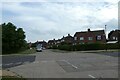
9
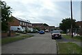
Beckfield Lane
Looking along Beckfield Lane in Acomb.
Image: © DS Pugh
Taken: 6 May 2020
0.24 miles