IMAGES TAKEN NEAR TO
Khyber Pass, WHITBY, YO21 3DQ
Introduction
This page details the photographs taken nearby to Khyber Pass, YO21 3DQ by members of the Geograph project.
The Geograph project started in 2005 with the aim of publishing, organising and preserving representative images for every square kilometre of Great Britain, Ireland and the Isle of Man.

There are currently over 7.5m images from over14,400 individuals and you can help contribute to the project by visiting https://www.geograph.org.uk
Image Map
Images are licensed for reuse under creativecommons.org/licenses/by-sa/2.0
Notes
- Clicking on the map will re-center to the selected point.
- The higher the marker number, the further away the image location is from the centre of the postcode.
Image Listing (2193 Images Found)
Images are licensed for reuse under creativecommons.org/licenses/by-sa/2.0
Image
Details
Distance
1
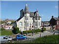
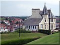
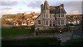
Streonshalh, Khyber Pass, Whitby
This building is built against a cliff and has three storeys below the two that can be seen in this image. The name is the old Saxon name for the town.
Image: © Humphrey Bolton
Taken: 30 Jul 2011
0.00 miles
2
Streonshalh, Khyber Pass (1)
Streonshalh is the Viking name for Whitby. The only information I been able to find about this impressive building is that it was once an hotel. It is now divided into apartments.
Image: © Mike Kirby
Taken: 6 Jul 2011
0.00 miles
3
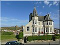
Zoom shot of Streonshalh Hotel, Whitby
The name Streonshalh relates to the early name of the settlement of Whitby.
Image: © Andrew Diack
Taken: 6 Aug 2016
0.00 miles
4
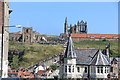
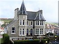
Streonshalh, Whitby
Streonshalh is the ancient name for Whitby.
This yellow brick and grey slate building is unusual in Whitby, red bricks and pantiles being more normal as can be seen in the background.
Also visible across the ravine (and in the next gridsquare east) are the famous steps. St Mary's Church, and Whitby Abbey.
Image: © Peter Church
Taken: 29 Sep 2007
0.00 miles
5
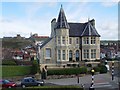
Streonshalh, Khyber Pass (2)
A side view of Streonshalh showing the large chimney stack. (A similar one graces the other end of the house). The only information I been able to find about this impressive building is that it was once an hotel. It is now divided into apartments.
Image: © Mike Kirby
Taken: 6 Jul 2011
0.01 miles
6
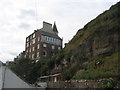
The back of Streonshalh
The house named Streonshalh, when viewed from the path down from Khyber Pass to Pier Road, has a very different appearance to its frontage ( Image] ), not least the fact that there appear to be three further floors below those visible from the front.
Image: © E Gammie
Taken: 12 Sep 2017
0.01 miles
7
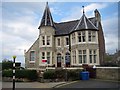
Streonshalh, Cliff Street, Whitby
Probably built as a pair of houses in the 19th century, this has been a hotel but appears to have reverted to private occupation. Confusingly, another B&B establishment in the town now uses the same name, which was that of the town in the 7th century.
Image: © Stephen Craven
Taken: 3 Sep 2024
0.01 miles
8
Streonshalh
This lovely building, once a hotel, is now flats.
Image: © Michael Dibb
Taken: 17 Sep 2017
0.01 miles
9
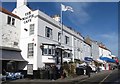
The famous Magpie Cafe
The Magpie must be one of England's best know fish and chip cafes. Unusual not to find a queue outside, but then it is around 11.30am on a Sunday morning.
Image: © Gordon Hatton
Taken: 7 Feb 2016
0.01 miles
10
View over Whitby Harbour
This is an evening view late October over Whitby Harbour and the Church. The Victorian style building in the front is a Hotel called Strenshalh which is the Viking name for Whitby. Hotel dates from around 1925. Whitby has a strange feature that the sun sets although West, it appears to set over the Spa.
Image: © roger nightingale
Taken: 20 Oct 2014
0.01 miles