IMAGES TAKEN NEAR TO
Abbey Inn Yard, Flowergate, WHITBY, YO21 3BQ
Introduction
This page details the photographs taken nearby to Abbey Inn Yard, Flowergate, YO21 3BQ by members of the Geograph project.
The Geograph project started in 2005 with the aim of publishing, organising and preserving representative images for every square kilometre of Great Britain, Ireland and the Isle of Man.

There are currently over 7.5m images from over14,400 individuals and you can help contribute to the project by visiting https://www.geograph.org.uk
Image Map (Loading...)


Getting Data...Please wait
Leaflet Map data © OpenStreetMap
Images are licensed for reuse under creativecommons.org/licenses/by-sa/2.0
Notes
- Clicking on the map will re-center to the selected point.
- The higher the marker number, the further away the image location is from the centre of the postcode.
Image Listing (1695 Images Found)
Images are licensed for reuse under creativecommons.org/licenses/by-sa/2.0
Image
Details
Distance
1
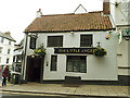
The Little Angel, Flowergate, Whitby
One of many pubs in the town centre, this one is listed grade II (list entry 1281253) because behind the 19th century exterior are an older 18th century building incorporating 12th century masonry.
Image: © Stephen Craven
Taken: 10 Aug 2019
0.00 miles
2
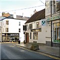
The Little Angel & An 18th century Mounting Block
The Grade II listed https://historicengland.org.uk/listing/the-list/list-entry/1281253 Little Angel Image dates from 1811. The 18th century worn mounting block outside on Flowergate is also Grade II listed https://historicengland.org.uk/listing/the-list/list-entry/1148271
Image: © Gerald England
Taken: 17 Dec 2018
0.01 miles
3

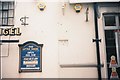
The Sign of The Little Angel
The sign for the Little Angel Image
Image: © Gerald England
Taken: 17 Dec 2018
0.01 miles
4
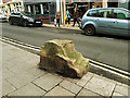
Old mounting block, Flowergate, Whitby
The block is outside the Little Angel pub Image and is separately listed Grade II (but associated as a group with the pub itself). Flowergate has been one of the principal streets of the town since Norman times, and under the same name since c.1220, but the mounting block is believed only to date from the 18th century.
Image: © Stephen Craven
Taken: 10 Aug 2019
0.01 miles
5
Boundary marker on Flowergate
Boundary marker between Whitby and Ruswarp parishes on the boundary between the Little Angel Inn at 18 Flowergate and 19 Flowergate.
W R
P
W=Whitby to the left, R=Ruswarp to the right
P=Parish
Image: © J G Harston
Taken: Unknown
0.01 miles

7

Boundary marker on Brunswick Street
Boundary marker between Whitby and Ruswarp parishes next to 15 Brundwick Street.
R W
P
R=Ruswarp to the left, W=Whitby to the right
P=Parish
The boundary marker is very weathered. It is embedded into the last remains of a wall that formed part of Flora Castle, that Flowergate was named after.
Image: © J G Harston
Taken: Unknown
0.01 miles
8
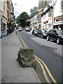
Mounting block, Flowergate
A grade II listed mounting block of C18 origin, comprising a stone block with two very worn steps. Located outside The Little Angel Public House.
LBS Number: 326759
Image: © Mike Kirby
Taken: 5 Jul 2010
0.01 miles
9
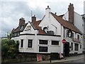
The Little Angel Public House, Flowergate
A grade II building dated C19, but parts of the inn go back to the C18.
LBS Number: 326758
Image: © Mike Kirby
Taken: 5 Jul 2010
0.01 miles
10
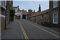
Brunswick Street
A narrow one way street with several places of worship along its length.
Image: © Malcolm Neal
Taken: 27 Jul 2021
0.01 miles