IMAGES TAKEN NEAR TO
St. Hildas Gardens, WHITBY, YO21 3AA
Introduction
This page details the photographs taken nearby to St. Hildas Gardens, YO21 3AA by members of the Geograph project.
The Geograph project started in 2005 with the aim of publishing, organising and preserving representative images for every square kilometre of Great Britain, Ireland and the Isle of Man.

There are currently over 7.5m images from over14,400 individuals and you can help contribute to the project by visiting https://www.geograph.org.uk
Image Map (Loading...)


Getting Data...Please wait
Leaflet Map data © OpenStreetMap
Images are licensed for reuse under creativecommons.org/licenses/by-sa/2.0
Notes
- Clicking on the map will re-center to the selected point.
- The higher the marker number, the further away the image location is from the centre of the postcode.
Image Listing (453 Images Found)
Images are licensed for reuse under creativecommons.org/licenses/by-sa/2.0
Image
Details
Distance
1
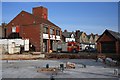
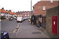
Whitby Fire Station
A view that's soon likely to disappear when it will be obscured by the new building in the foreground.
Image: © Mick Garratt
Taken: 9 Feb 2008
0.02 miles
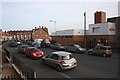
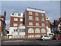
2
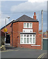
St John Ambulance Brigade, Whitby
Situated on Back St Hilda's Terrace. On the far left of the picture is an old mounting block.
Image: © Pauline E
Taken: 25 Feb 2014
0.03 miles
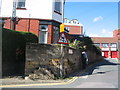
3
St. Johns Ambulance Whitby HQ
On Back St. Hilda's Terrace. Notice left of centre at the base of the lamp post with the orange CCTV sign there is a flight of stone steps that would have been used to mount horses.
Image: © Mick Garratt
Taken: 9 Feb 2008
0.03 miles
4

Whitby fire station
Whitby fire station, Back Saint Hildas Terrace, Whitby, North Yorkshire. As mentioned in Image, this is now the only view of the fire station possible from this side, with building works now completed.
Image: © Kevin Hale
Taken: 5 Jun 2009
0.03 miles
5
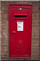
Elizabeth II Postbox, Whitby Delivery Office
Set into a wall on Crescent Avenue, outside the Royal Mail Delivery Office.
Image: © Mark Anderson
Taken: 4 Jun 2017
0.04 miles
6
Crescent Avenue
A closer view of the postbox can be seen here: Image
Image: © Mark Anderson
Taken: 4 Jun 2017
0.04 miles
8
St Hilda's Gardens
What looks like old mounting steps associated with the stone wall at the corner of St Hilda's Gardens and Back St Hilda's Terrace next to a building of a later date. In the background, right, are the doors of Whitby fire station. Dormer windows at the rear of the Union Mill building can be seen in the middle distance.
Image: © E Gammie
Taken: 13 Sep 2017
0.05 miles
9
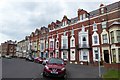
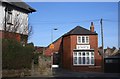
Crescent Avenue, Whitby
A terrace of guest houses and flats; the triangular bay windows are a curious feature
Image: © David Smith
Taken: 16 Jun 2015
0.05 miles
10
Union Mill
Union Mill was situated on this site in Upgang Road,now occupied by an apartment development of the same name, (Union Mill Apartments), and prior to that by Harrisons Showroom Garage.
The idea to build a mill came about in March 1800 when a group of concerned local businessmen held a meeting at The White Horse and Griffin Inn. In the late 18th C the yields for grain crops varied considerably. In the last decade there were a series of poor harvests and as bread was a staple food, the poor were the first to suffer. The group formed Union Mill Society, which later became incorporated into Whitby Union Mill Industrial and Provident Society Ltd, the papers and minutes of meetings are currently held by Whitby Literary and Philosophical Society. The mill provided reduced cost grain for local poor people and at cost for members/shareholder of the union. Each member had their own ticket which was punched on each batch of grain received. The foundation stone for Union Mill was laid by T.Fishburn and T.Broderick in June 1800. The mill suffered storm damage in Oct 1880 and again in July 1888. It was demolished or taken down to ground floor level in 1923.
Image: © Pauline E
Taken: 25 Feb 2014
0.05 miles