IMAGES TAKEN NEAR TO
Easton Lane, WHITBY, YO21 2LG
Introduction
This page details the photographs taken nearby to Easton Lane, YO21 2LG by members of the Geograph project.
The Geograph project started in 2005 with the aim of publishing, organising and preserving representative images for every square kilometre of Great Britain, Ireland and the Isle of Man.

There are currently over 7.5m images from over14,400 individuals and you can help contribute to the project by visiting https://www.geograph.org.uk
Image Map
Images are licensed for reuse under creativecommons.org/licenses/by-sa/2.0
Notes
- Clicking on the map will re-center to the selected point.
- The higher the marker number, the further away the image location is from the centre of the postcode.
Image Listing (27 Images Found)
Images are licensed for reuse under creativecommons.org/licenses/by-sa/2.0
Image
Details
Distance
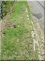
2
Easton Lane stone trod 4
Stone trod at Kadelands House near Ainthorpe.
Image: © T Eyre
Taken: 23 Apr 2021
0.01 miles
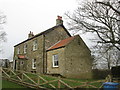
3
Kadelands House
On the Northern side of Easton Lane, near Ainthorpe.
Image: © Colin Grice
Taken: 27 May 2007
0.02 miles
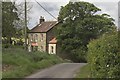
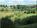
4
Kadelands Farm in Esk Dale
Kadelands Farm is located on Easton Road - just east of Kadelands House. Both properties are situated on the south side of Esk Dale, some of which can be seen just beyond the building. The small village of Danby can be seen on the horizon on the opposite side of the Dale.
Image: © Philip Barker
Taken: 29 Nov 2009
0.03 miles
5
Easton Lane stone trod 3
Here the trod has crossed to the other side of the road near Kadelands House.
Image: © T Eyre
Taken: 23 Apr 2021
0.05 miles
6
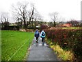
Public footpath to Easton Road and Kadelands House
This photograph shows the public footpath to Kadelands House which lies on the minor road that runs between Ainthorpe (to the left) and Danby Castle (to the right). Kadelands House can be seen just above the two walkers and Kadelands Farm lies just to the right (the red-roofed building). Esk Dale lies just beyond the buildings. Across the dale, on the horiozon, the small village of Danby is just visible.
Image: © Philip Barker
Taken: 29 Nov 2009
0.07 miles

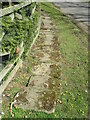
9
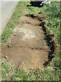
Easton Lane stone trod 5
More stones uncovered by pulling the grass back.
Image: © T Eyre
Taken: 23 Apr 2021
0.10 miles
10
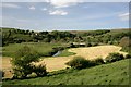
Fields North of Easton Lane
Looking north, the river and railway bridge being in the next square. The Moors Centre should be just made out behind the bridge.
Image: © Mick Garratt
Taken: 22 May 2007
0.11 miles