IMAGES TAKEN NEAR TO
Moorlands Park, WHITBY, YO21 2HE
Introduction
This page details the photographs taken nearby to Moorlands Park, YO21 2HE by members of the Geograph project.
The Geograph project started in 2005 with the aim of publishing, organising and preserving representative images for every square kilometre of Great Britain, Ireland and the Isle of Man.

There are currently over 7.5m images from over14,400 individuals and you can help contribute to the project by visiting https://www.geograph.org.uk
Image Map
Images are licensed for reuse under creativecommons.org/licenses/by-sa/2.0
Notes
- Clicking on the map will re-center to the selected point.
- The higher the marker number, the further away the image location is from the centre of the postcode.
Image Listing (68 Images Found)
Images are licensed for reuse under creativecommons.org/licenses/by-sa/2.0
Image
Details
Distance
1
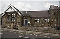
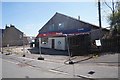
Castleton Village Hall
Being used as the Polling Station - 5th May 2011
Local election of councillors and the voting reform referendum.
Image: © Colin Grice
Taken: 5 May 2011
0.04 miles
3
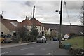
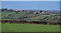
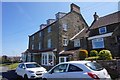
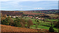
High Castleton
Looking down the village towards the school.
On old maps, High Castleton was separate from the lower part of the village, modern housing as seen here has filled in the gap over the last50 years or so.
Image: © Colin Grice
Taken: 3 Apr 2006
0.05 miles
5
High Castleton
High Castleton seen from Tofts Lane.
Image: © Peter McDermott
Taken: 20 Dec 2011
0.07 miles
6
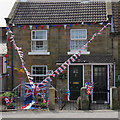
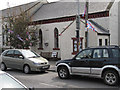
Decorations for the Royal wedding
The flags and bunting are 'off the shelf' but in the garden some special home-made items are rather fun.
Image: © Colin Grice
Taken: 5 May 2011
0.07 miles
8
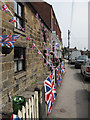
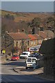
Royal wedding decorations
Castleton High street, near the Cooperative supermarket
There was a street party here on the big day, with tables set out in the road and a traffic diversion.
Image: © Colin Grice
Taken: 5 May 2011
0.08 miles
10
Castleton
Castleton is built on a ridge of high ground overlooking the River Esk. It takes its name from the castle that Robert de Brus built when he was granted lands by the king at the end of the 11th century. He later acquired further lands in the North East and south west Scotland becoming the 1st Lord of Annandale and establishing a dynasty that produced a king, Robert the Bruce of Scotland.
But at Castleton he was a mere Baron. The Reverend Atkinson in his book 'Forty Years in a Moorland Parish' recalls an old story that the baron “came in with the Conqueror”. As he is generally thought nowadays to have been born about 1070 if this story is true it must have been as a twinkle in his father’s eye.
De Brus’s stay in Castleton must have been quite short for he next built Skelton Castle. This was a strategically better location that overlooked the lowest fording of Skelton Beck where the Baron could control the transport of fish and salt from the coast south. He was also a monastic founder, establishing Gisborough Priory.
From my blog: https://fhithich.wordpress.com/2015/12/06/castleton/
Image: © Mick Garratt
Taken: 6 Dec 2015
0.08 miles