IMAGES TAKEN NEAR TO
High Street, WHITBY, YO21 2DB
Introduction
This page details the photographs taken nearby to High Street, YO21 2DB by members of the Geograph project.
The Geograph project started in 2005 with the aim of publishing, organising and preserving representative images for every square kilometre of Great Britain, Ireland and the Isle of Man.

There are currently over 7.5m images from over14,400 individuals and you can help contribute to the project by visiting https://www.geograph.org.uk
Image Map (Loading...)


Getting Data...Please wait
Leaflet Map data © OpenStreetMap
Images are licensed for reuse under creativecommons.org/licenses/by-sa/2.0
Notes
- Clicking on the map will re-center to the selected point.
- The higher the marker number, the further away the image location is from the centre of the postcode.
Image Listing (69 Images Found)
Images are licensed for reuse under creativecommons.org/licenses/by-sa/2.0
Image
Details
Distance
1
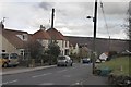
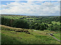
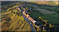
High Castleton
Looking down the village towards the school.
On old maps, High Castleton was separate from the lower part of the village, modern housing as seen here has filled in the gap over the last50 years or so.
Image: © Colin Grice
Taken: 3 Apr 2006
0.03 miles
2
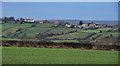
High Castleton
High Castleton seen from Tofts Lane.
Image: © Peter McDermott
Taken: 20 Dec 2011
0.03 miles
5
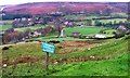
High Castleton view
Looking NW from the bench at High Castleton.
Image: © T Eyre
Taken: 7 Jul 2021
0.04 miles
7
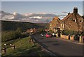
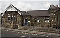
High Castleton
The top part of the village.
Image: © Colin Grice
Taken: 26 May 2006
0.07 miles
8
Sign, High Castleton
Looking down across the Esk Valley. The "Danby Court Leet" referred to on the sign is a survivor of the ancient manorial court system. It is held here Image every October.
Image: © Mick Garratt
Taken: 24 Nov 2006
0.07 miles
9
High Castleton
Castleton village has gradually extended and filled in along the ridge from the original smaller settlement - mainly below the school. However there were a few houses further up known as High Castleton even a couple of hundred years ago.
Image: © Colin Grice
Taken: 4 Aug 2014
0.07 miles
10
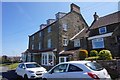
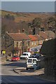
Castleton Village Hall
Being used as the Polling Station - 5th May 2011
Local election of councillors and the voting reform referendum.
Image: © Colin Grice
Taken: 5 May 2011
0.07 miles