IMAGES TAKEN NEAR TO
Aislaby, WHITBY, YO21 1TG
Introduction
This page details the photographs taken nearby to YO21 1TG by members of the Geograph project.
The Geograph project started in 2005 with the aim of publishing, organising and preserving representative images for every square kilometre of Great Britain, Ireland and the Isle of Man.

There are currently over 7.5m images from over14,400 individuals and you can help contribute to the project by visiting https://www.geograph.org.uk
Image Map
Images are licensed for reuse under creativecommons.org/licenses/by-sa/2.0
Notes
- Clicking on the map will re-center to the selected point.
- The higher the marker number, the further away the image location is from the centre of the postcode.
Image Listing (39 Images Found)
Images are licensed for reuse under creativecommons.org/licenses/by-sa/2.0
Image
Details
Distance
1
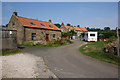
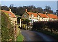
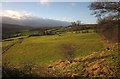
Thistle Grove
A small collection of cottages in a very scenic setting on the side of Eskdale. I am sure they are all holiday cottages now.
Image: © Bill Boaden
Taken: 5 Sep 2014
0.01 miles
3
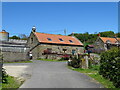
Thistle Grove
The listed farmhouse http://list.english-heritage.org.uk/resultsingle.aspx?uid=1148953&searchtype=mapsearch is seen from the Esk Valley Walk.
Image: © Derek Harper
Taken: 30 Dec 2012
0.01 miles
5
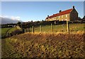
Thistle Grove
Another view of the farmhouse http://list.english-heritage.org.uk/resultsingle.aspx?uid=1148953&searchtype=mapsearch and associated buildings also seen in http://www.geograph.org.uk/search.php?i=39120853 .
Image: © Derek Harper
Taken: 30 Dec 2012
0.02 miles
6
Esk Valley Walk at Thistle Grove
Following bridleway 300002 along the paved trod past the farm shown in Image
Image: © Derek Harper
Taken: 30 Dec 2012
0.02 miles
7
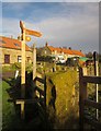
Footpath sign at Thistle Grove
With stile for walkers and gate for those requiring it (it's a bridleway) on the Esk Valley Walk. In the background is the listed farmhouse http://list.english-heritage.org.uk/resultsingle.aspx?uid=1148953&searchtype=mapsearch .
Image: © Derek Harper
Taken: 30 Dec 2012
0.03 miles
8
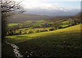
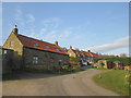
Thistle Grove
The red-roofed farmhouse across the fields is described at http://list.english-heritage.org.uk/resultsingle.aspx?uid=1148953&searchtype=mapsearch . The Esk Valley Walk follows bridleway 300002 along a stone trod in the foreground, later passing the farm on its way up the valley. Up on the right is Lodge Farm.
Image: © Derek Harper
Taken: 30 Dec 2012
0.05 miles
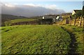
9
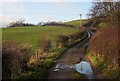
Sheep pasture, Thistle Grove
From the same spot on the Esk Valley Walk as Image], with the Walk following bridleway 300002 along the fence on the left, and Lodge Farm up to the right from Thistle Grove.
Image: © Derek Harper
Taken: 30 Dec 2012
0.05 miles
10
Track to Lodge Farm
With a hill to climb from Thistle Grove. This is the route of bridleway 300002 and of the Esk Valley Walk, which leaves the track at the further gate to strike out across fields to the left.
Image: © Derek Harper
Taken: 30 Dec 2012
0.07 miles