IMAGES TAKEN NEAR TO
South View, WHITBY, YO21 1PQ
Introduction
This page details the photographs taken nearby to South View, YO21 1PQ by members of the Geograph project.
The Geograph project started in 2005 with the aim of publishing, organising and preserving representative images for every square kilometre of Great Britain, Ireland and the Isle of Man.

There are currently over 7.5m images from over14,400 individuals and you can help contribute to the project by visiting https://www.geograph.org.uk
Image Map
Images are licensed for reuse under creativecommons.org/licenses/by-sa/2.0
Notes
- Clicking on the map will re-center to the selected point.
- The higher the marker number, the further away the image location is from the centre of the postcode.
Image Listing (235 Images Found)
Images are licensed for reuse under creativecommons.org/licenses/by-sa/2.0
Image
Details
Distance
1
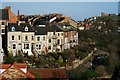
Windsor Terrace
Enjoying panoramic views over the Esk.
Image: © Mick Garratt
Taken: 14 Jan 2007
0.05 miles
2
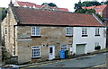
Waterstead cottages
Two cottages on the outskirts of the town. They were probably built as a pair but recent rendering has given them very different appearances.
Image: © Graham Horn
Taken: 17 Sep 2011
0.06 miles
3
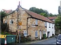
Waterstead Cottages
The cottages are in Waterstead Lane.
Image: © Michael Dibb
Taken: 17 Sep 2017
0.06 miles
4
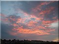
Sunset over Windsor Terrace
After a day of thunderstorms, the setting sun reflected in the clouds.
Image: © Mike Kirby
Taken: 7 Jul 2011
0.07 miles
5

View down Bog Hall
A view down Bog Hall with 18thcentury buildings on the right and modern development at the bottom of the street. Beyond, a large modern housing complex on the other side of the River Esk.
Image: © Christopher Hall
Taken: 1 Jul 2014
0.07 miles
6

Path leaves the road
The footpath leading to Whitby Bridge on the A171 leaves Windsor Terrace. The footpath is part of the Esk Valley Walk long distance path.
Image: © Michael Dibb
Taken: 17 Sep 2017
0.08 miles
7
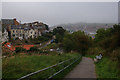
Path on Airy Hill on a misty day
Looking towards the centre of Whitby, but just near the sea, the visibility is limited.
Image: © Bill Boaden
Taken: 5 Sep 2014
0.08 miles
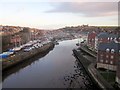
8

Railway by the River Esk
The railway engineers used the gentle gradients of the river to overcome the hilliness of the local terrain. This image from high up near the A171 road bridge is rich in detail.
Many yachts are still out of the water prior to summer outings.
Pantile rooftops are typical in this area.
The ruined abbey stands on the skyline.
Image: © Peter Church
Taken: 29 Mar 2008
0.09 miles
9

Railway Cottages
Recently built on the site of former railway sidings, these cottages are mostly holiday lets.
Image: © Michael Dibb
Taken: 17 Sep 2017
0.09 miles
10
River Esk at Whitby
A winter morning version of the scene from Whitby Bridge in Image, with new apartment buildings at Whitehall Landing on the right, and the abbey on the horizon.
Image: © Derek Harper
Taken: 30 Dec 2012
0.09 miles