IMAGES TAKEN NEAR TO
Moor Lane, WHITBY, YO21 1AX
Introduction
This page details the photographs taken nearby to Moor Lane, YO21 1AX by members of the Geograph project.
The Geograph project started in 2005 with the aim of publishing, organising and preserving representative images for every square kilometre of Great Britain, Ireland and the Isle of Man.

There are currently over 7.5m images from over14,400 individuals and you can help contribute to the project by visiting https://www.geograph.org.uk
Image Map (Loading...)


Getting Data...Please wait
Leaflet Map data © OpenStreetMap
Images are licensed for reuse under creativecommons.org/licenses/by-sa/2.0
Notes
- Clicking on the map will re-center to the selected point.
- The higher the marker number, the further away the image location is from the centre of the postcode.
Image Listing (10 Images Found)
Images are licensed for reuse under creativecommons.org/licenses/by-sa/2.0
Image
Details
Distance
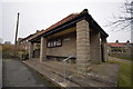
1
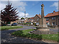
Aislaby war memorial
Situated at the junction of Moor Lane and Egton Road
Image: © Stephen McCulloch
Taken: 19 May 2008
0.08 miles
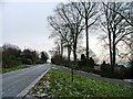
2
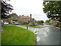
Road junction and war memorial, Aislaby
Image: © Humphrey Bolton
Taken: 5 Aug 2020
0.09 miles
3

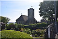
St.Margaret's church
Aislaby parish church by E.H.Smales 1896-7
Image: © Richard Croft
Taken: 8 Sep 2011
0.10 miles
5
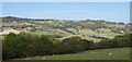
River Esk valley
The left bank of the Esk valley, taken from near Caley Becks Farm on the Eskdaleside road between Sleights and Grosmont. The village of Aislaby is near the skyline.
Image: © M H Evans
Taken: 2 Oct 2018
0.12 miles
9
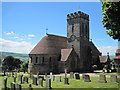
St Margaret C of E Church.
Only built in 1896 prior to that the dead had to be taken to Lythe for burial.
Image: © Martin Dawes
Taken: 16 Jun 2009
0.14 miles
10
Aislaby
Looking east from near the junction to the private road, also used as a Public Bridleway, to Home Farm.
Image: © Mick Garratt
Taken: 11 Feb 2006
0.17 miles