IMAGES TAKEN NEAR TO
Nessgate, YORK, YO1 9NP
Introduction
This page details the photographs taken nearby to Nessgate, YO1 9NP by members of the Geograph project.
The Geograph project started in 2005 with the aim of publishing, organising and preserving representative images for every square kilometre of Great Britain, Ireland and the Isle of Man.

There are currently over 7.5m images from over14,400 individuals and you can help contribute to the project by visiting https://www.geograph.org.uk
Image Map
Images are licensed for reuse under creativecommons.org/licenses/by-sa/2.0
Notes
- Clicking on the map will re-center to the selected point.
- The higher the marker number, the further away the image location is from the centre of the postcode.
Image Listing (3097 Images Found)
Images are licensed for reuse under creativecommons.org/licenses/by-sa/2.0
Image
Details
Distance
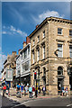
1
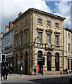
1-3 Nessgate, York
A noble palazzo on a very tall ground floor. By J.B. & W. Atkinson, 1839. Grade II listed.
Built for the Yorkshire Agricultural and Commercial Bank, it was a branch of Waterstone's but they appear to have moved on.
Image: © Stephen Richards
Taken: 13 May 2013
0.01 miles
2
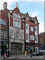
3-7 Coppergate, York
An Edwardian pair with hints of Arts & Crafts. The left-hand section was built in 1908, dated between carved figures (Image]), the right-hand section c1902 by Hornsey & Monkman. Grade II listed.
Shops occupied at the time by fashion chain, Urban Outfitters.
Image: © Stephen Richards
Taken: 13 May 2013
0.01 miles
3
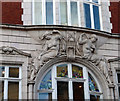
Detail of 3-7 Coppergate, York
Two partially clad female figures, each no doubt representing something significant, between which are the date of the building, 1908, and the initials GWH.
Full view: Image
Image: © Stephen Richards
Taken: 13 May 2013
0.01 miles
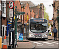
4

Whitby Coastliner bus
A Leeds - Whitby Coastliner No. 840 service turns from Bridge Street into Clifford Street.
Image: © The Carlisle Kid
Taken: 24 Apr 2014
0.01 miles
5
York Sightseeing bus
At the junction of Coppergate and Castle Gate.
Image: © The Carlisle Kid
Taken: 24 Apr 2014
0.01 miles
6
York Park & Ride bus
A Monks Cross No. 9 at the junction of Coppergate and Castle Gate.
Image: © The Carlisle Kid
Taken: 24 Apr 2014
0.01 miles
7

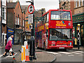
Nessgate
Looking along Nessgate at VKH674, an East Yorkshire Albion Aberdonian.
Image: © DS Pugh
Taken: 17 Oct 2021
0.01 miles
8
High Ousegate
Looking along High Ousegate from its junction with Spurriegate and Nessgate. The building on the corner, 1 Nessgate, was built in 1839 for the Yorkshire Agricultural and Commercial Bank, a company which failed in 1842, although maps suggest that it continued to be used as a bank until at leastthe late 20th Century. It now houses a branch of the clothes retailer, Fat Face. Grade II listed - see www.historicengland.org.uk/listing/the-list/list-entry/1257090.
Image: © Ian Capper
Taken: 20 Jul 2017
0.01 miles
9

Benchmark on Waterstones, High Ousegate
Ordnance Survey cut mark benchmark described on the Bench Mark Database at http://www.bench-marks.org.uk/bm37564
Image: © Roger Templeman
Taken: 16 Apr 2011
0.02 miles
10
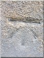
Ordnance Survey Cut Mark
This OS cut mark can be found on the wall of Waterstones. It marks a point 14.612m above mean sea level.
Image: © Adrian Dust
Taken: 8 Nov 2013
0.02 miles