IMAGES TAKEN NEAR TO
St. Helens View, The Green, YORK, YO19 6SP
Introduction
This page details the photographs taken nearby to St. Helens View, The Green, YO19 6SP by members of the Geograph project.
The Geograph project started in 2005 with the aim of publishing, organising and preserving representative images for every square kilometre of Great Britain, Ireland and the Isle of Man.

There are currently over 7.5m images from over14,400 individuals and you can help contribute to the project by visiting https://www.geograph.org.uk
Image Map
Images are licensed for reuse under creativecommons.org/licenses/by-sa/2.0
Notes
- Clicking on the map will re-center to the selected point.
- The higher the marker number, the further away the image location is from the centre of the postcode.
Image Listing (100 Images Found)
Images are licensed for reuse under creativecommons.org/licenses/by-sa/2.0
Image
Details
Distance
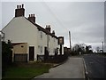
1
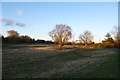
Towards Stillingfleet Beck
Seen from The Green.
Image: © DS Pugh
Taken: 11 Jan 2014
0.07 miles
2
Stillingfleet bridge
Part of the bridge over Stillingfleet beck.
Image: © DS Pugh
Taken: 10 Feb 2008
0.08 miles
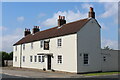
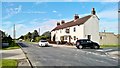
3
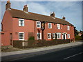
The Cross Keys, Stillingfleet
The Cross Keys is a Sam Smiths Public house and does sell a nice pint of beer at a good price.
Image: © Ian S
Taken: 30 Oct 2010
0.08 miles
4
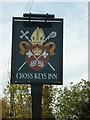
The sign for the Cross Keys
The Cross Keys Inn is on the corner of Church Hill and Cawood Road in Stillington. It is a Sam Smiths Public House, just one of around 350 in Britain.
Image: © Ian S
Taken: 30 Oct 2010
0.08 miles
5
Cross Keys Inn
One of the pubs in Stillingfleet. The main village is to the left.
Image: © DS Pugh
Taken: 8 Jan 2012
0.08 miles
6
Cross Keys Inn, Stillingfleet
Located on Cawood Road, Stillingfleet
Image: © Chris Heaton
Taken: 26 Jul 2021
0.08 miles
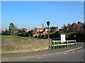
7
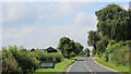
Approaching Stillingfleet from the East
Image: © Chris Heaton
Taken: 26 Jul 2021
0.09 miles
8
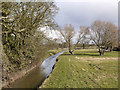
Stillingfleet Beck
Stillingfleet Beck passes through the village of Stillingfleet and feeds into the River Ouse a little over a mile from this location. The image was recorded from a bridge carrying the B1222 across the beck; the bridge has a bronze plaque telling of a flood there in March 1947 at a depth of 21 feet.
Image: © Trevor Littlewood
Taken: 11 Mar 2013
0.09 miles
10
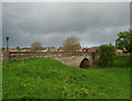
Bridge, Stillingfleet
The single-arch bridge, under which flows the eponymous beck, dates from c1820. The present lamps are 1992 replacements of the 1902 originals. Grade II listed.
Image: © Stephen Richards
Taken: 13 May 2013
0.09 miles