IMAGES TAKEN NEAR TO
Derwent Estate, YORK, YO19 5QL
Introduction
This page details the photographs taken nearby to Derwent Estate, YO19 5QL by members of the Geograph project.
The Geograph project started in 2005 with the aim of publishing, organising and preserving representative images for every square kilometre of Great Britain, Ireland and the Isle of Man.

There are currently over 7.5m images from over14,400 individuals and you can help contribute to the project by visiting https://www.geograph.org.uk
Image Map (Loading...)


Getting Data...Please wait
Leaflet Map data © OpenStreetMap
Images are licensed for reuse under creativecommons.org/licenses/by-sa/2.0
Notes
- Clicking on the map will re-center to the selected point.
- The higher the marker number, the further away the image location is from the centre of the postcode.
Image Listing (14 Images Found)
Images are licensed for reuse under creativecommons.org/licenses/by-sa/2.0
Image
Details
Distance
1
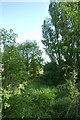
Former railway
Once the course of the Derwent Valley Light Railway. Viewed from York Road bridge.
Image: © DS Pugh
Taken: 28 May 2023
0.04 miles
2
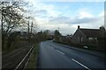
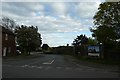
York Road from the former rail bridge
The railway is long gone, but the bridge remains.
Image: © DS Pugh
Taken: 30 Dec 2021
0.05 miles
3
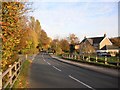
Edge of Dunnington
Taken from the old railway bridge in Dunnington.
Image: © DS Pugh
Taken: 4 Nov 2007
0.06 miles
4

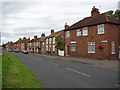
Pavement in Dunnington
Looking along York Road.
Image: © DS Pugh
Taken: 28 May 2023
0.15 miles
5
York Street, Dunnington
York Street, Dunnington.
Image: © DS Pugh
Taken: 11 Sep 2005
0.17 miles
6
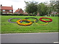
Owlwood Lane
Looking across York Street from Church Lane in Dunnington. The sign tells a little of the history for the Derwent Valley Light Railway.
Image: © DS Pugh
Taken: 15 May 2020
0.22 miles


10
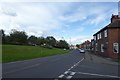
York Street
Looking along York Street from the junction with Owlwood Lane. Note the horse and cart model on the grass verge.
Image: © DS Pugh
Taken: 5 Aug 2017
0.24 miles