IMAGES TAKEN NEAR TO
Spring Bank Avenue, YORK, YO19 5PZ
Introduction
This page details the photographs taken nearby to Spring Bank Avenue, YO19 5PZ by members of the Geograph project.
The Geograph project started in 2005 with the aim of publishing, organising and preserving representative images for every square kilometre of Great Britain, Ireland and the Isle of Man.

There are currently over 7.5m images from over14,400 individuals and you can help contribute to the project by visiting https://www.geograph.org.uk
Image Map (Loading...)


Getting Data...Please wait
Leaflet Map data © OpenStreetMap
Images are licensed for reuse under creativecommons.org/licenses/by-sa/2.0
Notes
- Clicking on the map will re-center to the selected point.
- The higher the marker number, the further away the image location is from the centre of the postcode.
Image Listing (46 Images Found)
Images are licensed for reuse under creativecommons.org/licenses/by-sa/2.0
Image
Details
Distance
1
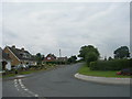
Church Balk - viewed from Church Street
Image: © Betty Longbottom
Taken: 30 Jul 2011
0.06 miles
3
Roadside Sculpture - Eastfield Lane
Image: © Betty Longbottom
Taken: 30 Jul 2011
0.08 miles
4
Church House - The Copper Beeches - off Church Street
Image: © Betty Longbottom
Taken: 30 Jul 2011
0.08 miles
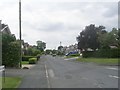
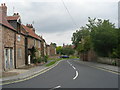
5

Eastfield Lane - viewed from Church Street
Image: © Betty Longbottom
Taken: 30 Jul 2011
0.08 miles
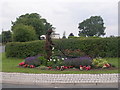
6

Dunnington War Memorial
The war memorial is in St Nicholas's churchyard, in the centre of the village.
Image: © William Metcalfe
Taken: 13 Apr 2007
0.09 miles
7
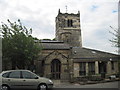
St Nicholas Dunnington Parish Church
Early Norman but with many alterations. In this photo, the upper tower is 15th century, the porch is 1839-41 and the building to the right of the porch built in the late 1980's by R.G.Sims houses an entrance hall, meeting room, choir vestry and kitchen.
Image: © Martin Dawes
Taken: 11 May 2011
0.10 miles
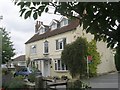
8

A Water Tower House
Still on the O/S maps as a water tower but obviously lived in. Any problems with damp?
Image: © Martin Dawes
Taken: 11 May 2011
0.10 miles
9
Church Street - viewed from St Nicholas' Church
Image: © Betty Longbottom
Taken: 30 Jul 2011
0.11 miles
10
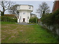
Water tower conversion
A former water tower has been converted into a private dwelling, viewed from the public footpath leading to it.
Image: © William Metcalfe
Taken: 13 Apr 2007
0.12 miles