IMAGES TAKEN NEAR TO
Upper Carr Lane, PICKERING, YO18 7JP
Introduction
This page details the photographs taken nearby to Upper Carr Lane, YO18 7JP by members of the Geograph project.
The Geograph project started in 2005 with the aim of publishing, organising and preserving representative images for every square kilometre of Great Britain, Ireland and the Isle of Man.

There are currently over 7.5m images from over14,400 individuals and you can help contribute to the project by visiting https://www.geograph.org.uk
Image Map
Images are licensed for reuse under creativecommons.org/licenses/by-sa/2.0
Notes
- Clicking on the map will re-center to the selected point.
- The higher the marker number, the further away the image location is from the centre of the postcode.
Image Listing (4 Images Found)
Images are licensed for reuse under creativecommons.org/licenses/by-sa/2.0
Image
Details
Distance
1
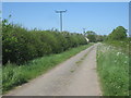
Carr Lane
Upper Carr Farm on the left.
Image: © Jonathan Thacker
Taken: 25 May 2012
0.02 miles

3
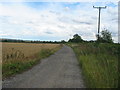
Track to Thornton le Dale
Rough track between Upper Carr and Thornton le Dale. Suitable for walkers, cyclists, horseriders and tractors.
Image: © Phil Catterall
Taken: 31 Jul 2006
0.19 miles
4

Tall trees at the caravan and camping site
Upper Carr Holiday Park also has a friendly tearoom.
Image: © Pauline E
Taken: 6 Sep 2012
0.23 miles