IMAGES TAKEN NEAR TO
Wharram, MALTON, YO17 9TL
Introduction
This page details the photographs taken nearby to YO17 9TL by members of the Geograph project.
The Geograph project started in 2005 with the aim of publishing, organising and preserving representative images for every square kilometre of Great Britain, Ireland and the Isle of Man.

There are currently over 7.5m images from over14,400 individuals and you can help contribute to the project by visiting https://www.geograph.org.uk
Image Map
Images are licensed for reuse under creativecommons.org/licenses/by-sa/2.0
Notes
- Clicking on the map will re-center to the selected point.
- The higher the marker number, the further away the image location is from the centre of the postcode.
Image Listing (19 Images Found)
Images are licensed for reuse under creativecommons.org/licenses/by-sa/2.0
Image
Details
Distance
1
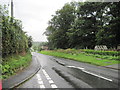
A Wet Day in Wharram le Street
The B1248 runs through the village, in this direction towards Malton.
Image: © Martin Dawes
Taken: 10 Aug 2011
0.03 miles
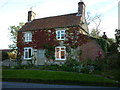
3
Stone houses at the southern edge of Wharram le Street
The B1248 on the edge of the village
Image: © David Smith
Taken: 19 Jun 2015
0.03 miles
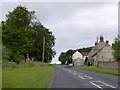
5
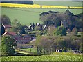
Wharram le Street from the north
Seen from the junction of Broad Balk and High Street
Image: © Paul Harrop
Taken: 4 May 2017
0.06 miles
7
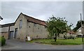
Barns on the main street, Manor Farm, Wharram le Street
Stone barns which face away from the road through the village.
Image: © David Smith
Taken: 19 Jun 2015
0.06 miles
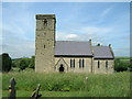
8
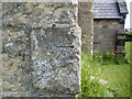
Benchmark on a church
The OS description is ST MARYS CH TWR W FACE SW ANG. The church is in Image
Image: © Neville Goodman
Taken: 5 Jun 2018
0.07 miles
9
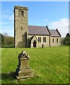
St Mary?s, Wharram le Street
Small village church dating from the Late Saxon period. Judging by the state of the churchyard shown in Image, someone has got a grip on the grounds maintenance in the past 12 years.
Image: © Paul Harrop
Taken: 4 May 2017
0.07 miles
10
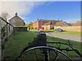
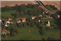
Wharram le Street
Looking across the B1248 towards Red House Farm. The large item of vintage agricultural machinery in the foreground is kept presumably for decorative purposes in front of Manor Farm.
Image: © Paul Harrop
Taken: 4 May 2017
0.08 miles