IMAGES TAKEN NEAR TO
Norton Road, MALTON, YO17 9RA
Introduction
This page details the photographs taken nearby to Norton Road, YO17 9RA by members of the Geograph project.
The Geograph project started in 2005 with the aim of publishing, organising and preserving representative images for every square kilometre of Great Britain, Ireland and the Isle of Man.

There are currently over 7.5m images from over14,400 individuals and you can help contribute to the project by visiting https://www.geograph.org.uk
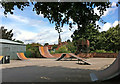
Image Map
Images are licensed for reuse under creativecommons.org/licenses/by-sa/2.0
Notes
- Clicking on the map will re-center to the selected point.
- The higher the marker number, the further away the image location is from the centre of the postcode.
Image Listing (274 Images Found)
Images are licensed for reuse under creativecommons.org/licenses/by-sa/2.0
Image
Details
Distance
2
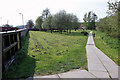
The Centenary Way in Norton
The Centenary Way is a long distance footpath (83 miles) which links York with the Yorkshire Wolds Way and the Cleveland Way. See http://www.ldwa.org.uk/ldp/members/show_path.php?path_id=64 for walking information. The route was devised to celebrate the 100th anniversary of Yorkshire County Council.
Image: © Peter Church
Taken: 24 Apr 2009
0.02 miles
3
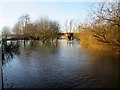
River Derwent in flood at Malton 27th Dec 2015 (6)
Over the flood defence wall alongside Norton Road looking through the riverside park, the lamp post is on the footpath, behind the trees to the left is the skate board park it is behind the flood defence wall, this can be seen going right behind the trees
Image: © Martin Dawes
Taken: 27 Dec 2015
0.03 miles
4
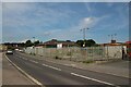
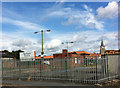
Former Northern Electic depot, Malton
A disused Electricity Network maintenance depot on Norton Road in Malton.
Image: © Graham Robson
Taken: 15 Jun 2022
0.03 miles
5
Derelict premises, Malton
Close to the river and prone to flooding. Buildings beyond are Morrisons supermarket and St Leonard's Church.
Image: © Pauline E
Taken: 28 Jul 2013
0.03 miles
6
River Derwent in flood at Malton 27th Dec 2015 (5)
From the top of one of the Skateboard Park ramps looking over the flood defence wall, the trees are in a riverside park with seats and picnic tables
Image: © Martin Dawes
Taken: 27 Dec 2015
0.03 miles
7
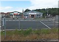
Commercial premises to the east of Malton Station
Image: © Barbara Carr
Taken: 22 Jun 2013
0.04 miles
8
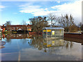
Morrisons car park under water
To the right, over the wall, you can see the high water level of the Derwent.
Image: © Pauline E
Taken: 27 Nov 2012
0.05 miles
9
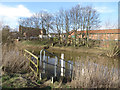
Flood gauge by the River Derwent
Across the river is the converted mill and to the right, Morrisons supermarket.
Image: © Pauline E
Taken: 28 Feb 2014
0.06 miles
10
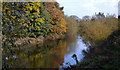
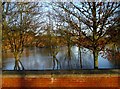
River Derwent in Malton
Autumnal colours reflected in the still waters of the River Derwent
Image: © John Sparshatt
Taken: 27 Oct 2012
0.06 miles