IMAGES TAKEN NEAR TO
Eddlethorpe, MALTON, YO17 9QT
Introduction
This page details the photographs taken nearby to YO17 9QT by members of the Geograph project.
The Geograph project started in 2005 with the aim of publishing, organising and preserving representative images for every square kilometre of Great Britain, Ireland and the Isle of Man.

There are currently over 7.5m images from over14,400 individuals and you can help contribute to the project by visiting https://www.geograph.org.uk
Image Map
Images are licensed for reuse under creativecommons.org/licenses/by-sa/2.0
Notes
- Clicking on the map will re-center to the selected point.
- The higher the marker number, the further away the image location is from the centre of the postcode.
Image Listing (5 Images Found)
Images are licensed for reuse under creativecommons.org/licenses/by-sa/2.0
Image
Details
Distance
1
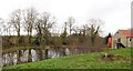
Mill dam at Manor Farm
This is curious as the millpond here isn't shown on my older 2000 edition of the OS map, yet it is shown on the 2015 edition. The pond is also absent from old OS 6" maps dating back over a century, but it is on first edition maps of circa 1860.
The building to the right is shown as 'Old Corn Mill' on early 20thC maps and is now offices for the agricultural company here. One has to assume that the millpond has recently been restored to something like its original size and shape.
Image: © Gordon Hatton
Taken: 18 Feb 2019
0.14 miles
2
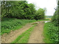
Path near Manor Farm
It gets narrower ahead.
Image: © T Eyre
Taken: 12 May 2018
0.15 miles
4
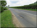
Bad potholes
Bad potholes on the road near Westow.
Image: © T Eyre
Taken: 12 May 2018
0.22 miles
5
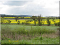
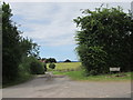
Farmland off Ruffin Lane
Pasture and crop fields.
Image: © Pauline E
Taken: 24 Apr 2012
0.24 miles