IMAGES TAKEN NEAR TO
George Cartwright Close, MALTON, YO17 8EL
Introduction
This page details the photographs taken nearby to George Cartwright Close, YO17 8EL by members of the Geograph project.
The Geograph project started in 2005 with the aim of publishing, organising and preserving representative images for every square kilometre of Great Britain, Ireland and the Isle of Man.

There are currently over 7.5m images from over14,400 individuals and you can help contribute to the project by visiting https://www.geograph.org.uk
Image Map
Images are licensed for reuse under creativecommons.org/licenses/by-sa/2.0
Notes
- Clicking on the map will re-center to the selected point.
- The higher the marker number, the further away the image location is from the centre of the postcode.
Image Listing (44 Images Found)
Images are licensed for reuse under creativecommons.org/licenses/by-sa/2.0
Image
Details
Distance
1

Flood defences across the Derwent
Protecting the railway line and the town of Norton.
Image: © Pauline E
Taken: 25 Aug 2011
0.09 miles
2
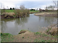
River Derwent
Sinking back to more normal levels after a wet winter.
Image: © Pauline E
Taken: 15 Mar 2014
0.12 miles
3

Redundant bridge pier by the River Derwent
A leftover from the dismantled railway. Once part of the Malton to Driffield Railway. http://en.wikipedia.org/wiki/Malton_and_Driffield_Railway
Image: © Pauline E
Taken: 25 Aug 2011
0.14 miles
4

Cottages, Norton
On the junction of Vine Street and Commercial Street.
Image: © Pauline E
Taken: 2 Jan 2012
0.15 miles
5
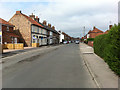
Parliament Street
The houses on the left back on to the allotments.
Image: © Pauline E
Taken: 1 Aug 2013
0.15 miles
6

Mill Street meets Commercial Street
B1248 route through town to Driffield and Beverley.
Image: © Pauline E
Taken: 2 Jan 2012
0.16 miles
7

Boardwalk, Lady Spring Wood
After a very cold start to the Spring this year, there are signs of green shoots emerging at last.
Image: © Pauline E
Taken: 10 Apr 2013
0.16 miles
8
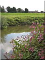
The River Derwent
With Himalayan Balsam colonising the banks. View towards Norton. The Derwent rises on Fylingdales Moor, flows southwards as far as its confluence with the River Hertford then westwards through the Vale of Pickering, south through Kirkham Gorge and the Vale of York and joins the River Ouse at Barmby on the Marsh.
Image: © Pauline E
Taken: 25 Aug 2011
0.16 miles
9
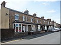
Bay-windowed houses, Parliament Street, Norton
On the south side of the road.
Image: © Christine Johnstone
Taken: 4 Aug 2018
0.16 miles
10

Kingfisher mosaic
One of many lining the boardwalks through Lady Spring Wood.
Image: © Pauline E
Taken: 25 Aug 2011
0.16 miles