IMAGES TAKEN NEAR TO
Wellgarth, MALTON, YO17 6SS
Introduction
This page details the photographs taken nearby to Wellgarth, YO17 6SS by members of the Geograph project.
The Geograph project started in 2005 with the aim of publishing, organising and preserving representative images for every square kilometre of Great Britain, Ireland and the Isle of Man.

There are currently over 7.5m images from over14,400 individuals and you can help contribute to the project by visiting https://www.geograph.org.uk
Image Map
Images are licensed for reuse under creativecommons.org/licenses/by-sa/2.0
Notes
- Clicking on the map will re-center to the selected point.
- The higher the marker number, the further away the image location is from the centre of the postcode.
Image Listing (34 Images Found)
Images are licensed for reuse under creativecommons.org/licenses/by-sa/2.0
Image
Details
Distance
1
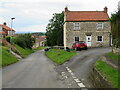
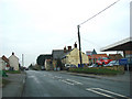
West Street, Swinton
Swinton consists of West, East and Middle Streets, but the vast majority of motorists will see none of these as they journey along the Malton to Helmsley road that cuts across the top of the village.
Image: © Gordon Hatton
Taken: 25 Jul 2023
0.05 miles
2
West Street, Swinton
A village on the B1257 between Amotherby and Broughton.
Image: © Pauline E
Taken: 4 Jun 2013
0.05 miles
3
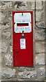
Swinton Letter Box
GR letter box in the wall of the former Swinton Post Office
Image: © David Rogers
Taken: 8 Mar 2009
0.06 miles
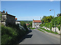
4
Dark sky over Swinton
Heading west past the Blacksmith's Arms pub.
Image: © Pauline E
Taken: 1 Oct 2012
0.06 miles

7
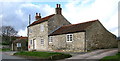
Swinton Post Office
Former post office on Swinton High Street.
Image: © David Rogers
Taken: 8 Mar 2009
0.11 miles
8
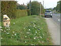
Old milepost
Looking in the direction of Malton the yarrow covered banking surrounds the milepost. This would have been forged at the Mattison foundry at the end of the 19thC or beginning of the 20thC. Grade II listed 1149123.
Image: © Chris Minto
Taken: 16 Oct 2023
0.12 miles
9
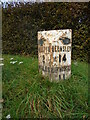
Old milepost
On the B1257 in Swinton this neglected milepost made by F Mattison and Co., Bedale is 60m east of East Street. On this autumn day surrounded by long grass and white yarrow plants. Kirkbymoorside is now spelt with the extra K.
Grade II listed 1149123.
Image: © Chris Minto
Taken: 16 Oct 2023
0.12 miles
10

West Street, Swinton
Showing position of Postbox No. YO17 95.
See Image] for close up.
Image: © JThomas
Taken: 19 Sep 2020
0.12 miles