IMAGES TAKEN NEAR TO
Eskdale Drive, BRIDLINGTON, YO16 6GS
Introduction
This page details the photographs taken nearby to Eskdale Drive, YO16 6GS by members of the Geograph project.
The Geograph project started in 2005 with the aim of publishing, organising and preserving representative images for every square kilometre of Great Britain, Ireland and the Isle of Man.

There are currently over 7.5m images from over14,400 individuals and you can help contribute to the project by visiting https://www.geograph.org.uk
Image Map
Images are licensed for reuse under creativecommons.org/licenses/by-sa/2.0
Notes
- Clicking on the map will re-center to the selected point.
- The higher the marker number, the further away the image location is from the centre of the postcode.
Image Listing (113 Images Found)
Images are licensed for reuse under creativecommons.org/licenses/by-sa/2.0
Image
Details
Distance
6
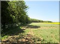
Wide uncultivated field margin alongside Crow Plantation
Field of Rape Seed
Image: © Martin Dawes
Taken: 29 May 2020
0.05 miles

8

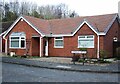
Bungalow off Thorntondale Drive, Bridlington
Image: © JThomas
Taken: 15 Nov 2012
0.06 miles

