IMAGES TAKEN NEAR TO
Northmoor, SCARBOROUGH, YO13 9QH
Introduction
This page details the photographs taken nearby to Northmoor, YO13 9QH by members of the Geograph project.
The Geograph project started in 2005 with the aim of publishing, organising and preserving representative images for every square kilometre of Great Britain, Ireland and the Isle of Man.

There are currently over 7.5m images from over14,400 individuals and you can help contribute to the project by visiting https://www.geograph.org.uk
Image Map
Images are licensed for reuse under creativecommons.org/licenses/by-sa/2.0
Notes
- Clicking on the map will re-center to the selected point.
- The higher the marker number, the further away the image location is from the centre of the postcode.
Image Listing (11 Images Found)
Images are licensed for reuse under creativecommons.org/licenses/by-sa/2.0
Image
Details
Distance
1
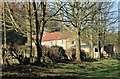
Wykeham Research Office
A Forestry Commission establishment.
Image: © Mick Garratt
Taken: 25 Aug 2012
0.02 miles
2
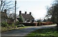
Houses at North Moor
North Moor is no more than a scattered hamlet at the southern edge of Wykeham Forest. The name doesn't appear on old maps and the only residence shown on maps of pre 1950 date is that of Wykeham Low Moor House in the same place as Wykeham Moor Cottages are shown on current OS maps. I suspect that the group of houses shown here may have been built for forestry workers as they first appear on the OS map of 1950.
Image: © Gordon Hatton
Taken: 25 Feb 2022
0.06 miles
3
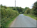
North Moor
Forestry Commission buildings.
Image: © Pauline E
Taken: 24 Jan 2015
0.08 miles
4
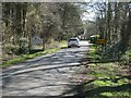
Forestry workers' house, North Moor
In the foreground is Moor Road. Sited at the junction of a forestry track with this is a group of four pairs of semi-detached houses built for forestry workers. They look to date from the 1950s.
Image: © Christopher Hall
Taken: 11 Sep 2014
0.08 miles
6
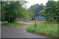
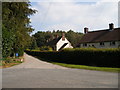
Welcome to North Moor
A sign on Moor Road at the northern end of this tiny community on the edge of the forest.
Image: © Gordon Hatton
Taken: 25 Feb 2022
0.20 miles
7
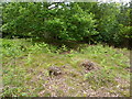
Tumulus, Wykeham Forest
A small tumulus on an overgrown forest track, north east of the Forestry hamlet of North Moor. The tumulus was cleared of much of the undergrowth and small trees covering it in 2007.
Image: © Elaine Stockdale
Taken: 12 Jun 2011
0.23 miles