IMAGES TAKEN NEAR TO
Ebberston, SCARBOROUGH, YO13 9PB
Introduction
This page details the photographs taken nearby to YO13 9PB by members of the Geograph project.
The Geograph project started in 2005 with the aim of publishing, organising and preserving representative images for every square kilometre of Great Britain, Ireland and the Isle of Man.

There are currently over 7.5m images from over14,400 individuals and you can help contribute to the project by visiting https://www.geograph.org.uk
Image Map
Images are licensed for reuse under creativecommons.org/licenses/by-sa/2.0
Notes
- Clicking on the map will re-center to the selected point.
- The higher the marker number, the further away the image location is from the centre of the postcode.
Image Listing (6 Images Found)
Images are licensed for reuse under creativecommons.org/licenses/by-sa/2.0
Image
Details
Distance
1
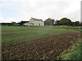
Kirkdale Buildings at the head of Kirk Dale
From the farm access road which goes into Hagg Side Lane down to the A170
Image: © Martin Dawes
Taken: 25 Oct 2017
0.00 miles
2
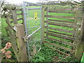
NEW
Large kissing gate
At the entrance to a deer enclosure at the top of Kirk Dale.
Image: © T Eyre
Taken: 6 Apr 2024
0.10 miles
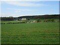
3
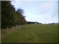
View across the farmland towards Pheasant Hill Farm
Image: © Phil Catterall
Taken: 13 Feb 2007
0.14 miles
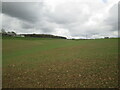
4
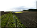
Track down towards Oxdale
A bird scarer can be seen on the left of the picture.
Image: © Phil Catterall
Taken: 13 Feb 2007
0.17 miles
6
The head of Kirk Dale north of Ebberston
Pheasant Hill Farm is to the left
Image: © Martin Dawes
Taken: 29 Apr 2021
0.23 miles