IMAGES TAKEN NEAR TO
Garth End Road, SCARBOROUGH, YO13 9JH
Introduction
This page details the photographs taken nearby to Garth End Road, YO13 9JH by members of the Geograph project.
The Geograph project started in 2005 with the aim of publishing, organising and preserving representative images for every square kilometre of Great Britain, Ireland and the Isle of Man.

There are currently over 7.5m images from over14,400 individuals and you can help contribute to the project by visiting https://www.geograph.org.uk
Image Map
Images are licensed for reuse under creativecommons.org/licenses/by-sa/2.0
Notes
- Clicking on the map will re-center to the selected point.
- The higher the marker number, the further away the image location is from the centre of the postcode.
Image Listing (28 Images Found)
Images are licensed for reuse under creativecommons.org/licenses/by-sa/2.0
Image
Details
Distance
1
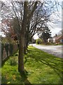
Commemorative trees, Garth End Road, West Ayton
A line of trees planted to commemorate Sir Winston Churchill
Image: © Christopher Hall
Taken: 1 May 2015
0.03 miles
2
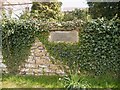
Stone plaque, Garth End Road, West Ayton
This plaque in a stone wall on Garth End Road refers to the commemorative trees shown in Image
Image: © Christopher Hall
Taken: 1 May 2015
0.03 miles
3
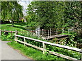
West Ayton Footbridge
Across the River Derwent near Low Mill but closed off.
Image: © David Rogers
Taken: 18 May 2009
0.05 miles
4
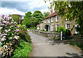
Hall Garth
Near Low Mill at West Ayton.
Image: © David Rogers
Taken: 18 May 2009
0.06 miles
5
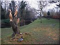
Carved tree by the River Derwent
This cherry tree on the bank of the Derwent just below the mill weir has recently been sculpted in the form of these birds. The Derwent forms the boundary between the parishes of East Ayton and West Ayton - this is the West Ayton bank.
Image: © Christopher Hall
Taken: 16 Mar 2015
0.09 miles
6
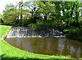
Low Mill Weir
Along the River Derwent at West Ayton.
Image: © David Rogers
Taken: 18 May 2009
0.10 miles
7
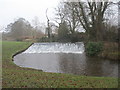
Weir on the River Derwent at West Ayton
The river is the boundary between East and West Ayton
Image: © Martin Dawes
Taken: 10 Jan 2018
0.11 miles
8

Yedmandale Road
West Ayton station on the Pickering & Seamer branch line was close to these cottages near Low Mill.
Image: © David Rogers
Taken: 18 May 2009
0.13 miles
9
Former Forge Valley station, 1992
View SW, towards Pickering: ex-NER Pickering - Seamer (- Scarborough) line. The line had been closed back on 5/6/50, but the station has survived as a private house - with little else washing-lines on the platforms.
Image: © Ben Brooksbank
Taken: 20 Jun 1992
0.13 miles
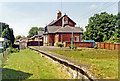
10
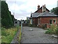
Forge Valley railway station (site), Yorkshire
Opened in 1882 by the North Eastern Railway on the line from Pickering to Seamer, this station closed in 1950. The station is actually located in the village of West Ayton.
View south west towards Sawdon and Pickering.
More details can be found at http://www.disused-stations.org.uk/f/forge_valley/index.shtml.
Image: © Nigel Thompson
Taken: 16 Aug 2009
0.13 miles