IMAGES TAKEN NEAR TO
Wykeham Street, SCARBOROUGH, YO12 7SA
Introduction
This page details the photographs taken nearby to Wykeham Street, YO12 7SA by members of the Geograph project.
The Geograph project started in 2005 with the aim of publishing, organising and preserving representative images for every square kilometre of Great Britain, Ireland and the Isle of Man.

There are currently over 7.5m images from over14,400 individuals and you can help contribute to the project by visiting https://www.geograph.org.uk
Image Map (Loading...)


Getting Data...Please wait
Leaflet Map data © OpenStreetMap
Images are licensed for reuse under creativecommons.org/licenses/by-sa/2.0
Notes
- Clicking on the map will re-center to the selected point.
- The higher the marker number, the further away the image location is from the centre of the postcode.
Image Listing (115 Images Found)
Images are licensed for reuse under creativecommons.org/licenses/by-sa/2.0
Image
Details
Distance
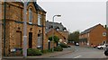
1
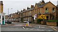
Wykeham Street
In 2004 Wykeham Street was voted Britain’s worst rat-run in a competition run by Transport 2000 and Sustrans. http://www.transport2000.org.uk/news/maintainNewsArticles.asp?NewsArticleID=150 http://www.transport2000.org.uk/news/maintainNewsArticles.asp?NewsArticleID=132 http://news.bbc.co.uk/1/hi/england/north_yorkshire/3179769.stm http://www.bbc.co.uk/radio4/today/listenagain/ram/today4_longworth_20030826.ram
This photograph is looking toward its western end (ahead) and was taken from Manor Road (foreground, left and right).
To the right is the Image junction with Scalby Road at the Image
For a more easterly (ahead) photograph of Wykeham Street, click here Image
Image: © Alan Walker
Taken: 2 May 2007
0.01 miles
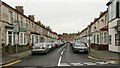
2
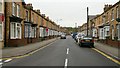
Wykeham Street
Looking westerly along Wykeham Street from its junction with Image toward its junction with Image
Some 20metres behind (easterly) the viewpoint Wykeham Street has a junction with Image (left, south-easterly) and Image (right, northerly).
For a photograph of Wykeham Street from approximately the same viewpoint but looking in the opposite (easterly) direction, click here Image
For a photograph of the western (ahead) end of Wykeham Street, click here Image
Road name information from OS Maps at:-
Elgin, http://www.elgin.gov.uk/
Image: © Alan Walker
Taken: 2 May 2007
0.02 miles
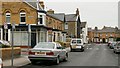
3
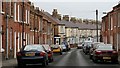
Hampton Road
This east north-easterly looking photograph shows part of Hampton Road.
In the 1950’s the first of the white-brick faced houses with the facing door used to be a fish and chip shop.
For a more easterly (ahead) photograph of Hampton Road, click here Image
For a more westerly (behind the viewpoint) photograph of Hampton Road, click here Image
Road name information from OS Maps at:-
Elgin, http://www.elgin.gov.uk/
Image: © Alan Walker
Taken: 2 May 2007
0.03 miles
4
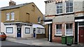
Two Properties
The two properties shown here in Image have been subject to a variety of uses over the years.
The one on the left, now called ‘Scaboro Aquatics’ used to be the archetypical corner shop in the 1950’s.
The other, a fish and chip shop in the 1950’s is now a private residence.
Image: © Alan Walker
Taken: 2 May 2007
0.04 miles
5
Sinclair Court
Off the western end of Image (right) and opposite the junction with Image, Sinclair Court was named after the builders yard that once occupied this location.
Image: © Alan Walker
Taken: 2 May 2007
0.05 miles
6
Hampton Road
Looking westerly along Hampton Road from its junction with, Image
For a more westerly (ahead) photograph of Hampton Road but looking back, toward this viewpoint, click here Image
Image: © Alan Walker
Taken: 2 May 2007
0.05 miles
7
St John?s Road
The photograph, which was taken from near its junction with Image (just ahead, left), is looking north north-westerly along St John’s Road toward its junction with Image (facing, ahead).
The building on the corner of St John’s Road and St John’s Avenue in recent years has been a Dental Technicians however in the 1950’s it was the archetypical corner shop.
Further ahead, after the black-faced end terrace, the white building on the corner of Image and St Johns Road was also a corner shop (known by many as Charlie’s).
For a more north north-westerly (ahead) photograph of St John's Road but looking back, toward this viewpoint, click here Image
For a more south south-easterly (behind the viewpoint) photograph of St John's Road but looking back in this direction click here Image
Road name information from OS Maps at:-
Elgin, http://www.elgin.gov.uk/
Image: © Alan Walker
Taken: 2 May 2007
0.06 miles
8
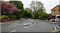
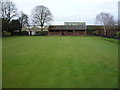
Manor Road
The photograph is looking ‘northerly’ along the southern end of Image
In the 1950’s behind the trees ahead (beyond the car) there used to be a small park with bowling green, swings and grassy area for ball games. Today, although the bowling green remains, the remainder of this space is used by the local council as a nursery for its gardens planting.
On the right is the roads junction with Image
Just after the road markings (arrows) there is a gap in the low wall on the left. This gap marks the entrance to a short Image that links Manor Road with Alexandra Park.
Some 40metres behind the viewpoint Manor Road meets Scalby Road at the Image
Image: © Alan Walker
Taken: 2 May 2007
0.06 miles
10
Off Hampton Road
In the 1950’s this short roadway off Image housed a number of business activities:
The building behind the parked vehicle (and the vehicle itself) are on the site of what used to be stables.
The stables were used to house a horse, a cart and an open landau that were owned by a Mr Briggs. Briggs used to earn a living by taking tourist for rides in the landau along the seafront and by transporting goods on the cart.
A garage opposite the stables was owned by a fruit and vegetable merchants called Richardson’s.
At the far end of the roadway and to the right there was a garage and store for a ‘Coca Cola’ distributor.
Image: © Alan Walker
Taken: 2 May 2007
0.06 miles