IMAGES TAKEN NEAR TO
Scholes Park Drive, SCARBOROUGH, YO12 6RD
Introduction
This page details the photographs taken nearby to Scholes Park Drive, YO12 6RD by members of the Geograph project.
The Geograph project started in 2005 with the aim of publishing, organising and preserving representative images for every square kilometre of Great Britain, Ireland and the Isle of Man.

There are currently over 7.5m images from over14,400 individuals and you can help contribute to the project by visiting https://www.geograph.org.uk
Image Map
Images are licensed for reuse under creativecommons.org/licenses/by-sa/2.0
Notes
- Clicking on the map will re-center to the selected point.
- The higher the marker number, the further away the image location is from the centre of the postcode.
Image Listing (180 Images Found)
Images are licensed for reuse under creativecommons.org/licenses/by-sa/2.0
Image
Details
Distance
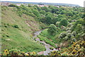
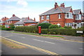
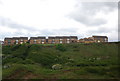
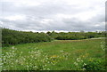
3
Houses on Scholes Park Road
Viewed from across the ravine of Scalby Beck.
Image: © Stephen Craven
Taken: 25 Mar 2017
0.09 miles
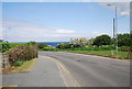
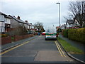
7
Bus stops, Scalby Mills Rd
The 3B bus stops at these stops.
Image: © N Chadwick
Taken: 30 May 2010
0.12 miles
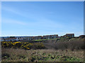
9
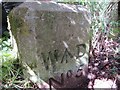
Old Boundary Marker near Scalby Beck, Newby and Scalby Parish
Estate Boundary Marker - War Department in parish of Newby And Scalby (Scarborough District), alongside footpath North of Scalby Beck, in the undergrowth.
Surveyed
Milestone Society National ID: YN_WDNEW05em
Image: © John S Turner
Taken: 5 May 2017
0.12 miles