IMAGES TAKEN NEAR TO
Middle Walk, SCARBOROUGH, YO12 6BJ
Introduction
This page details the photographs taken nearby to Middle Walk, YO12 6BJ by members of the Geograph project.
The Geograph project started in 2005 with the aim of publishing, organising and preserving representative images for every square kilometre of Great Britain, Ireland and the Isle of Man.

There are currently over 7.5m images from over14,400 individuals and you can help contribute to the project by visiting https://www.geograph.org.uk
Image Map
Images are licensed for reuse under creativecommons.org/licenses/by-sa/2.0
Notes
- Clicking on the map will re-center to the selected point.
- The higher the marker number, the further away the image location is from the centre of the postcode.
Image Listing (119 Images Found)
Images are licensed for reuse under creativecommons.org/licenses/by-sa/2.0
Image
Details
Distance
1
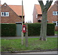
George V postbox on Broadway, Scarborough
Small 'Hovis top' post mounted box.
Postbox No. YO12 140.
See Image] for close up.
See Image] and Image] for context.
Image: © JThomas
Taken: 27 Feb 2016
0.02 miles
2
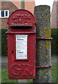
Close up, George V postbox on Broadway, Scarborough
Small 'Hovis top' post mounted box.
Postbox No. YO12 140.
See Image] for postbox.
Image: © JThomas
Taken: 27 Feb 2016
0.02 miles
3
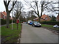
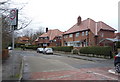
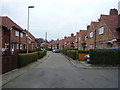
Broadway, Scarborough
Looking south east showing position of Postbox No. YO12 140.
Small 'Hovis top' post mounted box.
See Image] for postbox.
Image: © JThomas
Taken: 27 Feb 2016
0.02 miles
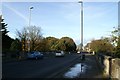
4
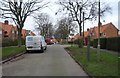
Broadway, Scarborough
Looking north west showing position of Postbox No. YO12 140.
Small 'Hovis top' post mounted box.
See Image] for postbox.
Image: © JThomas
Taken: 27 Feb 2016
0.02 miles
6
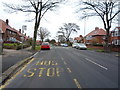
Bus stop on Northstead Manor Drive
Looking north.
Image: © JThomas
Taken: 20 Feb 2016
0.07 miles
8
Peasholm Glen Bridge
Peasholm Glen Bridge crosses Peasholm Beck which here is in quite a deep ravine known as Peasholm Glen, a public park. Peasholm Beck was the medieval northern boundary of Scarborough town. The building of the bridge facilitated the expansion of the town to the north such as the development of the Northstead Estate. The bridge was opened in 1932, the design engineers were Mouchel & Partners, the Borough Engineers Harry W. Smith and the architectural design by George W. Alderson.
Image: © Christopher Hall
Taken: 1 Dec 2013
0.10 miles
10
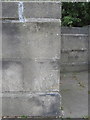
Bench mark on Peasholm Glen Bridge - N.W.
This Ordnance Survey bench mark is on the western parapet of Peasholm Glen Bridge, but not at the very northern end - see also Image There is another bench mark on the north eastern parapet opposite - see Image
Image: © John S Turner
Taken: 8 Jul 2010
0.10 miles